


Urban infill developments are slated to transform the vast industrial land between Charleston and North Charleston, South Carolina, known as "the Neck" area, into live-work communities that stitch the two cities together.
"Urban infill developments large and small, the type that brag of true sustainability because they are built around existing infrastructure and in tight spaces, are slated to transform a diverse tract of land that stretches from the Holy City at the foot of the Arthur Ravenel Jr. Bridge up to the shuttered Charleston Naval Base and into old North Charleston.
Considering the prime location of this property, in proximity to so many of the Lowcountry's main arteries, it's hard not to wonder why mass-scale development did not happen here sooner. It's downtown Charleston minus the parking headaches, an easy trip to Interstate 26, right off the foot of the Ravenel bridge and a quick hike to North Charleston.
But like a Southern conversation, this metamorphosis is slow-moving and prone to distraction."
Thanks to A. Lamar Calloway
FULL STORY: Uniting Development


The Simple Legislative Tool Transforming Vacant Downtowns
In California, Michigan and Georgia, an easy win is bringing dollars — and delight — back to city centers.
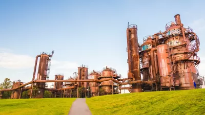
Revitalizing Cities Through Soil Health, Green Spaces, and Nature-Based Remediation
Investing in soil health, urban parks, and nature-based solutions for brownfield remediation is essential for creating resilient cities, restoring ecosystems, and improving community well-being.
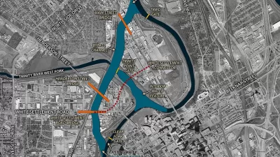
Report: Fort Worth’s Panther Island Should Emphasize Mixed Use, Walkability
Originally planned as a primarily residential development, the riverfront development could shift to a focus on entertainment, commerce, and outdoor recreation.

Maui's Vacation Rental Debate Turns Ugly
Verbal attacks, misinformation campaigns and fistfights plague a high-stakes debate to convert thousands of vacation rentals into long-term housing.

Planetizen Federal Action Tracker
A weekly monitor of how Trump’s orders and actions are impacting planners and planning in America.

San Francisco Suspends Traffic Calming Amidst Record Deaths
Citing “a challenging fiscal landscape,” the city will cease the program on the heels of 42 traffic deaths, including 24 pedestrians.

Defunct Pittsburgh Power Plant to Become Residential Tower
A decommissioned steam heat plant will be redeveloped into almost 100 affordable housing units.

Trump Prompts Restructuring of Transportation Research Board in “Unprecedented Overreach”
The TRB has eliminated more than half of its committees including those focused on climate, equity, and cities.

Amtrak Rolls Out New Orleans to Alabama “Mardi Gras” Train
The new service will operate morning and evening departures between Mobile and New Orleans.
Urban Design for Planners 1: Software Tools
This six-course series explores essential urban design concepts using open source software and equips planners with the tools they need to participate fully in the urban design process.
Planning for Universal Design
Learn the tools for implementing Universal Design in planning regulations.
Heyer Gruel & Associates PA
JM Goldson LLC
Custer County Colorado
City of Camden Redevelopment Agency
City of Astoria
Transportation Research & Education Center (TREC) at Portland State University
Jefferson Parish Government
Camden Redevelopment Agency
City of Claremont