Alternate routes provided by the app reduced the heat experienced during the walk by an average of 4.5 degrees.



A new app created by Arizona State University researchers lets users map out the shadiest walk to their destination to help them avoid the effects of extreme heat, which can reach deadly temperatures in the Southwestern summer.
As Joe Rojas-Burke explains in ASU News, "Cool Routes, an online tool developed by Ariane Middel and colleagues in The SHaDE Lab at ASU, chooses paths based on forecasts of mean radiant temperature, a measure of the total heat load experienced in a given location, including reflected heat and sun exposure."
The app, which updates itself hourly with weather data, uses more than just air or surface temperature, taking into account reflected heat and sun exposure. "In sun-blasted Phoenix, mean radiant temperature can exceed 150 degrees F in full sun but drop below 100 in the shade. Shade can make a real difference on people’s heat exposure on a hot, sunny day." In tests, the app identified cooler alternatives for 70% of trips and lowered the experienced heat load by about 4.5 degrees on average.
According to Rojas-Burke, "The current version covers ASU's Tempe campus, but it is an open-source framework that can be put to work in other cities to support walking, biking and public transit use."
Read the full story: New 'Cool Routes' app maps shadiest routes for your walk


Index Measures Impact of Heat on Pedestrian Activity
When heat and humidity are high, people are more likely to opt for cars when possible.
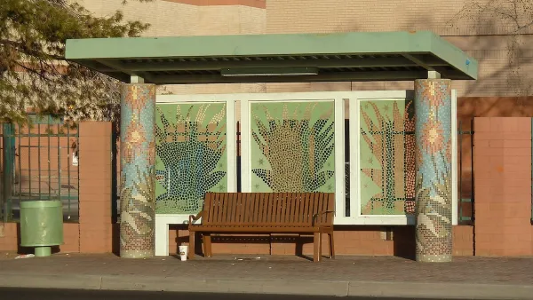
Phoenix Shade Plan Focuses on Bus Stops
The city’s updated Shade Master Plan calls for trees and built structures at bus stops to protect residents from heat.

Phoenix Announces Shade Action Plan
The city has outlined 11 strategic priorities aimed at addressing the risks of extreme heat and protecting vulnerable residents from its impacts.

Planetizen Federal Action Tracker
A weekly monitor of how Trump’s orders and actions are impacting planners and planning in America.

California plans to bury El Niño’s downpour
If the state plays its cards right, it may be able to store a billion acre-feet of El Niño’s water in aquifers.

Desperate measures: Advocates weigh draining Lake Powell to fill Colorado River
Draining the reservoir could reduce evaporation losses by a couple hundred thousand acre-feet.

Metra may invest $9.1 billion in regional rail
The agency released a draft of a study examining potential ways to offer more frequent train service.

California city breaks ground on transit connector
The project includes three mobility hubs and a pedestrian bridge.

After public outcry, Massachusetts city releases housing development tracker
Cambridge’s tracker currently shows 250 housing projects in various stages of development.

FREE Course: Walkable City 1: Why Walkability?
After describing his path towards focusing on walkability as the essence of good planning, Jeff Speck marches through his five principal reasons for making more walkable places.
Reinventing Malls: Planning Alchemy—Turning Gray Fields Into Gold
The course focuses on the opportunities and imperatives that shape reinvention of mall sites.

City of Rosemead
Rutgers University, Edward J. Bloustein School of Planning and Public Policy
One Hundred Miles
Hunter College, City University of New York (CUNY)
The Architects Foundation
University of Cincinnati Online
City of Cambridge
Montrose County
The Pocatello Development Authority