


Wildlife-vehicle collisions cost Americans over $8 billion annually. The solution can be simple — and stunning.
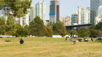
East of the world-famous Banff National Park, the Trans-Canada Highway weaves through Alberta’s Bow Valley, a high-speed artery that moves up to 30,000 vehicles a day. It is a critical economic and transportation corridor that links southern Alberta to major destinations west such as Banff and ultimately Vancouver and the Pacific coast. The highway crosses through the traditional territory of the Stoney Nakoda First Nations and some of the most scenic landscapes in Canada. Yet for wildlife, it has long been a significant barrier for migration and movement; a moving wall of noise, high speed metal, and life-threatening risk.
Wildlife-vehicle collisions (WVCs) are a prevalent problem, not just for the Trans-Canada but for roads and freeways all across North America, particularly in our vast stretches of untamed wilderness. In Canada, there are an average of 4 to 8 large animal collisions per hour, with an economic cost of approximately $800,000,000 annually. Even in Alberta, the province with the greatest number of constructed wildlife crossings, WVCs cost the province’s taxpayers approximately $300,000 per day. In the United States, where traffic volumes are significantly higher, so too are the impacts of WVCs with an estimated 2,700 daily collisions, costing Americans over $8,000,000,000 annually. These figures show the economic impact on humans but don't account for harm to wildlife and ecological networks.
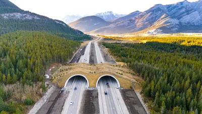
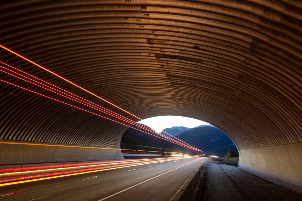
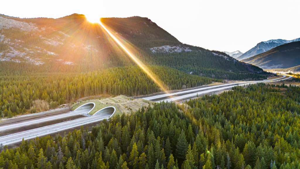
The Bow Valley Gap Wildlife Overpass, designed by our firm, DIALOG, and completed in 2024, is a modest but innovative intervention designed to reconnect disrupted wildlife corridors in this heavily trafficked region. It’s also the first wildlife overpass in Canada constructed outside of a national park. Quietly embedded in the landscape, this simple structure supports more than animals—it carries the idea that suburban and exurban infrastructure can be both well engineered and contextually sensitive.
Studied since 2012, the location of the Bow Gap overpass has long been notorious for collisions primarily involving elk and deer, but also moose, bears, and other smaller species. These incidents, on average over 60 per year, are not only detrimental to wildlife, but have had serious impacts to human health and safety, economic trade, and the surrounding natural environment. Wildlife migration routes have evolved over thousands of years and are not easy to shift, and with traffic volumes only increasing, this pristine stretch of the TCH had become a dangerous and high-profile hotspot. Something needed to be done.
A different kind of crossing
What makes the Bow Valley Gap Wildlife Overpass unique is not just its location, but its restrained engineering approach. Rather than a showy, architectural intervention, it’s a carefully calibrated structure designed to work with, not against, the surrounding topography and ecology.
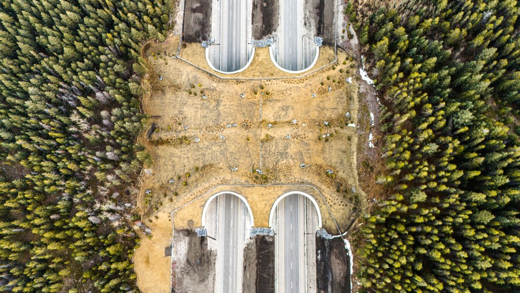
The design responds to the unique topography of its location and reflects the natural grade change as much as possible, seeking to create a habitat that feels safe and welcoming for its intended animal users. Decades of data informed the location decision, citing the crossing where it would have the most impact and balancing alignment with documented, evidenced based migration route and vehicular collision data. Fencing was used to direct animals to the crossing location, a gentle refinement to their intuitive movement patterns. From there, the structure was engineered to minimize disruption and impact —both for the animals above and the vehicles below.
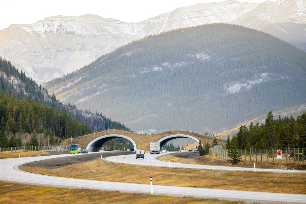
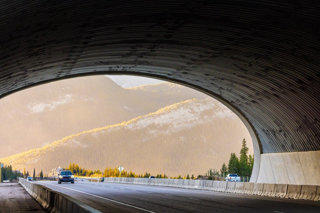
The structure is highly visible to motorists and care was required to develop an aesthetically pleasing design that reflects the character of the surrounding landscape context in which it is situated. The design team elected to use a beveled end to the arch, which was chosen to reflect the natural character of the surroundings. This detail allows the structure to appear more low-lying and mimics the local foothills emerging into a mountain backdrop. The beveled ends also help reduce the impacts of noise and light on wildlife by using the structure and the wider approach for wildlife is expected to enhance its tie into the environment and use. The result is a striking structure that appears to be built into the surrounding landscape rather than built onto it.
Simplicity was a principle, not a limitation. For wildlife, the experience is buffered by vegetation and localized berms to create a continuous, intuitive passage. For drivers, it’s barely noticeable — a seamless integration into the roadscape that avoids distraction.
Collaborative design, contextual response
Designing a wildlife crossing is already a challenging endeavour and one of the most significant constraints to address was balancing driver safety and experience with ecological function. That meant designing for clear sightlines of drivers, managing snow and stormwater and limiting impacts to efficient traffic flow. At the same time, the crossing needed to be quiet, sheltered, and vegetated enough to invite use by cautious animal species.
Collaboration was critical to balance these potentially competing objectives. The project brought together structural engineers, landscape architects, ecologists, and provincial regulators. Early coordination helped resolve issues ranging from fencing strategies to direct wildlife to the crossing, to how slope geometry would influence both the design of the arches and the anticipated animal movement across them.
While the final form of the crossing looks simple, getting there was not. Much of the design process was about resisting the impulse to over-complicate or deviate from the intuitive and ultimately elegant solution. One early design iteration featured more robust structural elements and decorative detailing, but these were ultimately pared back in favor of something more grounded and contextual.
There were also quieter design decisions that mattered. Planting strategies were developed to support natural cover and encourage animal movement, while also maintaining driver sightlines. Materials were chosen to weather well and recede visually.
It’s not a landmark in the traditional sense, but it is deeply intentional.
Signs of success
It’s early days, but the signs are promising. Wildlife cameras have already recorded and documented crossings by deer and coyotes, including during the winter shutdown in construction. Monitoring efforts will continue over the coming seasons to track use patterns and assess changes in WVCs.
Local response has been encouraging as well. Community members have expressed support for the project, and several municipalities have since inquired about the process behind it. The project is already prompting broader conversations about how to better integrate ecological thinking into regional growth planning.
Learning for the future
Perhaps the most important takeaway from the Bow Valley Gap Overpass project is that ecological infrastructure isn’t just for protected areas. Wildlife movement doesn’t stop at Park boundaries, and neither should our efforts to support it. We also can and should assess existing infrastructure in high-risk areas to identify opportunities to improve wildlife crossings. This approach of modifying or retrofitting existing structures tends to be more beneficial for smaller animals that are not necessarily the “focal” species but still provides meaningful improvement to ecological connectivity.
Continuous collaboration between the engineers and the wildlife biologists from the start of design should continue through the entire design process, supporting iteration and refinement as the project evolves. Wildlife exclusion fencing, a key element to the success of the wildlife overpass, should not be overlooked. More complex fencing alignment may be required, as projects are encroaching on both public and private land. This was not an issue on the Bow Valley Gap project which was bounded by public land on both sides.
The project also highlights the value of interdisciplinary collaboration. By bringing together diverse perspectives — ecological, technical, cultural — it was possible to create a structure that feels inevitable, rather than imposed. The overpass quietly demonstrates that well integrated design can change the way we move through and understand the landscaping, helping to mitigate the human imprint on the natural world.
This is a small project with big implications. It’s a reminder that planning and design, when done thoughtfully, can repair what infrastructure has fragmented. In a time of rapid development, shrinking public infrastructure budgets, and expanding ecological stress, projects like this ask us to think beyond efficiency and towards meaning.
Jill Robertson is an award-winning landscape architect whose experience crosses scales from detailed site design to visionary city-building. Her work focuses on the meaningful improvement of the natural world through thoughtful and articulate design interventions, and she is widely recognized for her ability to weave context-specificity into design narrative and celebrate the stories and ideas of the end users. Jill has been recognized by her peers as one of Canada’s emerging landscape architectural leaders, through recognition as one of the University of Guelph’s youngest and most notable alumnus and her induction into the Canadian Society of Landscape Architects College of Fellows.
Neil Robson is a Partner at DIALOG and leader of their bridge and civil infrastructure team. He has a long track record of successfully delivering transportation and infrastructure projects on time and budget for Alberta Transportation and Economic Corridors, Parks Canada, the City of Edmonton, and the City of Calgary. Included in those projects are four of the wildlife overpass crossings in Banff National Park, and the recently completed Bow Valley Gap Overpass near Canmore. He is also leading the team designing three additional wildlife crossings for the Province of Alberta.

Wildlife Rebounds After the Eaton Fire
Following the devastation of the Eaton Fire, the return of wildlife and the regrowth of native plants are offering powerful signs of resilience and renewal.
Tackling Soil Contamination With Nature-Based Solutions
Los Angeles County residents and experts are turning to nature-based methods like bioremediation to address long-standing and fire-exacerbated soil contamination without resorting to costly and disruptive removal.
Study: How Urban Parks Can Support Biodiversity
Conservation and recreation can go hand in hand in urban green spaces designed to serve both humans and local wildlife.

Rethinking Redlining
For decades we have blamed 100-year-old maps for the patterns of spatial racial inequity that persist in American cities today. An esteemed researcher says: we’ve got it all wrong.

Planetizen Federal Action Tracker
A weekly monitor of how Trump’s orders and actions are impacting planners and planning in America.

California High-Speed Rail's Plan to Right Itself
The railroad's new CEO thinks he can get the project back on track. The stars will need to align this summer.

Savannah Reduces Speed Limits on Almost 100 City Streets
The historic Georgia city is lowering speed limits in an effort to reduce road fatalities.

A Park Reborn: Resilience and Renewal in Fire-Stricken Altadena
Rebuilt in just two months after the devastating Eaton Fire, Loma Alta Park now stands as a symbol of community resilience and renewal, even as some residents hope recovery efforts will continue to support housing stability and long-term equity.

Spain Moves to Ban 66,000 Airbnbs
The national government is requiring the short-term rental operator to remove thousands of illegal listings from its site as part of an effort to stem a growing housing crisis.
Urban Design for Planners 1: Software Tools
This six-course series explores essential urban design concepts using open source software and equips planners with the tools they need to participate fully in the urban design process.
Planning for Universal Design
Learn the tools for implementing Universal Design in planning regulations.
City of Clovis
City of Moorpark
City of Camden Redevelopment Agency
City of Astoria
Transportation Research & Education Center (TREC) at Portland State University
Regional Transportation Commission of Southern Nevada
Toledo-Lucas County Plan Commissions