


An FRA study shows how new Amtrak lines could connect tens of millions more Americans to rail travel.
In a piece for Fast Company, Kristin Toussaint describes how 15 proposed new Amtrak routes could unlock rail travel for 39 million more Americans and serve over 60 new metro areas, as indicated in a map from the Federal Railroad Administration.
“With those rail lines, previously stranded regions of the country are suddenly connected with bright lines representing passenger rail. They would make the country’s rail network considerably fuller and would bring rail service to all of the lower 48 states,” Toussaint adds. “Less than 10% of riders on Amtrak’s current long-distance routes ride from end-to-end, the study notes, but what these routes do is connect people to all the urban and rural places in between.”
The study was the result of a directive that was part of the 2021 Bipartisan Infrastructure Law and was delivered to Congress this week. Public comments submitted as part of the study indicate strong public support for more intercity rail service. As Toussaint notes, “Amtrak itself saw record ridership in 2024, with new routes quickly surpassing expectations.”
Implementing all these new routes would take significant federal investment and planning. According to the study, “there is no sustained financial support or program to construct or operate the selected preferred route options.”
FULL STORY: If the government funded these Amtrak routes, 39 million more people would have rail access

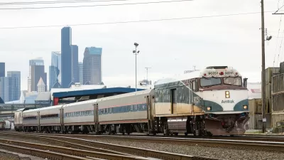
Amtrak Cascades Line Breaks Ridership Record
The route linking Portland, Seattle, and Vancouver, BC served nearly one million riders in 2024.
Opinion: Prioritize Amtrak, but Don’t Demonize Freight
A proposed bill would tighten enforcement of a 1973 law that gives passenger trains priority over freight shipments.

Gateway Tunnel Project Ready to Move Forward
The project is primarily funded through federal agencies and will improve a key link between New Jersey and New York City.

Planetizen Federal Action Tracker
A weekly monitor of how Trump’s orders and actions are impacting planners and planning in America.

Chicago’s Ghost Rails
Just beneath the surface of the modern city lie the remnants of its expansive early 20th-century streetcar system.

San Antonio and Austin are Fusing Into one Massive Megaregion
The region spanning the two central Texas cities is growing fast, posing challenges for local infrastructure and water supplies.

Since Zion's Shuttles Went Electric “The Smog is Gone”
Visitors to Zion National Park can enjoy the canyon via the nation’s first fully electric park shuttle system.

Trump Distributing DOT Safety Funds at 1/10 Rate of Biden
Funds for Safe Streets and other transportation safety and equity programs are being held up by administrative reviews and conflicts with the Trump administration’s priorities.

German Cities Subsidize Taxis for Women Amid Wave of Violence
Free or low-cost taxi rides can help women navigate cities more safely, but critics say the programs don't address the root causes of violence against women.
Urban Design for Planners 1: Software Tools
This six-course series explores essential urban design concepts using open source software and equips planners with the tools they need to participate fully in the urban design process.
Planning for Universal Design
Learn the tools for implementing Universal Design in planning regulations.
planning NEXT
Appalachian Highlands Housing Partners
Mpact (founded as Rail~Volution)
City of Camden Redevelopment Agency
City of Astoria
City of Portland
City of Laramie