


The app provides navigation using audio and haptic cues to improve accessibility for people with low vision.

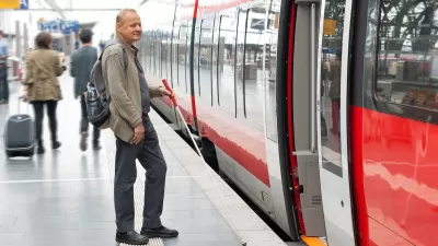
A mobile app helps transit riders with vision impairment plan trips more easily, interpreting signage and incorporating scheduling information. As Maylin Tu writes in Next City, the app was developed by Spain-based NaviLens and “uses codes posted at bus stops or in train stations to provide real-time navigation via audio and haptic (vibration) cues, directing the user from the elevator in a train station, for example, to a nearby bus stop.” Agencies including the New York City MTA have adopted the system. Last year, Vancouver’s TransLink agency launched a six-month pilot program at 16 stops to evaluate the effectiveness of the NaviLens system.
Like other accessibility features, designing public facilities for people with vision impairments can benefit other groups as well. “To improve wayfinding, [accessibility consultant Richard Marion] recommends that transit agencies focus on consistent and high-contrast signage across a region, so that people with some sight loss can easily distinguish between a no parking sign and a bus stop, for example, even if they don’t read braille. Making bus stops easy to identify would be helpful for wayfinding in general.”
FULL STORY: An App That Helps Riders With Vision Loss Navigate Complex Transit Systems


How to Improve Transit Accessibility
Over 13 million Americans face mobility challenges that limit their travel experience.

Website Streamlines Michigan Transit Information
The tool is designed to help people with disabilities navigate the state’s complex public transit network.
How Car Dependency Impacts People With Disabilities
People who are physically unable to drive can benefit from effective public transit systems and accessible, mixed-use neighborhoods.

Montreal Mall to Become 6,000 Housing Units
Place Versailles will be transformed into a mixed-use complex over the next 25 years.

Planetizen Federal Action Tracker
A weekly monitor of how Trump’s orders and actions are impacting planners and planning in America.

DARTSpace Platform Streamlines Dallas TOD Application Process
The Dallas transit agency hopes a shorter permitting timeline will boost transit-oriented development around rail stations.

Study: 4% of Truckers Lack a Valid Commercial License
Over 56% of inspected trucks had other violations.

Chicago Judge Orders Thousands of Accessible Ped Signals
Only 3% of the city's crossing signals are currently accessible to blind pedestrians.

Philadelphia Swaps Car Lanes for Bikeways in Unanimous Vote
The project will transform one of the handful of streets responsible for 80% of the city’s major crashes.
Urban Design for Planners 1: Software Tools
This six-course series explores essential urban design concepts using open source software and equips planners with the tools they need to participate fully in the urban design process.
Planning for Universal Design
Learn the tools for implementing Universal Design in planning regulations.
City of Mt Shasta
City of Camden Redevelopment Agency
City of Astoria
Transportation Research & Education Center (TREC) at Portland State University
US High Speed Rail Association
City of Camden Redevelopment Agency
Municipality of Princeton (NJ)