


The L.A. County Board of Supervisors just approved the Parks Needs Assessment Plus (PNA+), which highlights the need for transforming degraded lands such as landfills and oil fields into parks and open spaces, particularly in underserved communities.

What is the percentage of land area in Los Angeles County dedicated to regional recreation and conservation? Which areas of L.A. county should be prioritized for environmental conservation and restoration? What is the acreage of parkland in the rural portions of the county? How many miles of regional trails are there and where are they located?
The Los Angeles County Board of Supervisors just approved a study that answers these questions and more. Called the 2022 Parks Needs Assessment Plus (PNA+), this report complements and offers information not previously included in the 2016 Los Angeles Countywide Parks and Recreation Needs Assessment (PNA). Specifically, PNA+ contains data and analyses in support of expanding land conservation and restoration, transit to parks, and other strategies to meet regional and rural recreation needs, especially in the most vulnerable communities.
The PNA+ is L.A. County's 30x30 strategy which aligns with state and federal goals to conserve 30 percent of lands and coastal waters by the year 2030 to fight climate change and advance biodiversity and conservation. PNA+ addresses both environmental conservation and restoration. It identifies priority areas for environmental conservation which are areas that offer the most environmental benefits as measured by species diversity, significant habitat, habitat connectivity, proximity to a waterbody, and habitat type. Examples of these areas include portions of the Antelope Valley, Puente-Chino Hills Wildlife Corridor, San Gabriel Mountains, Santa Monica Mountains, and Santa Clarita Valley which are not currently owned and managed by public agencies and conservancies.
The study also calls out priority areas for environmental restoration. These are areas that have the most environmental burdens with respect to groundwater threat, hazardous waste, poor air and water quality, and pollution burden. Examples include oil fields (such as the Inglewood Oil Field in Baldwin Hills), brownfields, landfills (such as the Puente Hills Landfill), and other degraded lands which may be converted to parks and open space in the future. The restoration of degraded lands is of great importance and a matter of environmental justice in Los Angeles County where numerous underserved communities are plagued with environmental burdens.
Based on its key findings, PNA+ offers various recommendations and next steps which are explained in detail in the report and organized by the following categories: funding priorities; park, trail, and open space provision; collaboration and coordination; access and information; community engagement; and capacity building.
FULL STORY: LA County board adopts updated park needs assessment

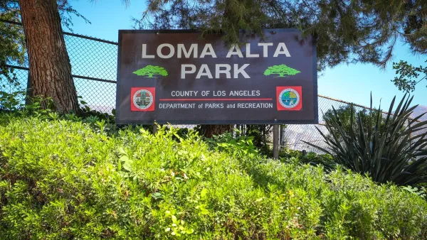
A Park Reborn: Resilience and Renewal in Fire-Stricken Altadena
Rebuilt in just two months after the devastating Eaton Fire, Loma Alta Park now stands as a symbol of community resilience and renewal, even as some residents hope recovery efforts will continue to support housing stability and long-term equity.
A Greener LA County: 623 Acres of New Parkland for Communities
Los Angeles County is investing $17 million to create 623 acres of new parks and open spaces, expanding access to nature, advancing equity, and enhancing community health and well-being.

Bringing Communities Together: Lunar New Year Festivities Across LA County
To celebrate the Lunar New Year, LA County Parks is hosting free community festivals at 61 parks, featuring cultural performances, food tastings, crafts, and interactive activities that honor the Year of the Snake and promote unity and tradition.

Planetizen Federal Action Tracker
A weekly monitor of how Trump’s orders and actions are impacting planners and planning in America.

Maui's Vacation Rental Debate Turns Ugly
Verbal attacks, misinformation campaigns and fistfights plague a high-stakes debate to convert thousands of vacation rentals into long-term housing.

San Francisco Suspends Traffic Calming Amidst Record Deaths
Citing “a challenging fiscal landscape,” the city will cease the program on the heels of 42 traffic deaths, including 24 pedestrians.

Amtrak Rolls Out New Orleans to Alabama “Mardi Gras” Train
The new service will operate morning and evening departures between Mobile and New Orleans.

The Subversive Car-Free Guide to Trump's Great American Road Trip
Car-free ways to access Chicagoland’s best tourist attractions.

San Antonio and Austin are Fusing Into one Massive Megaregion
The region spanning the two central Texas cities is growing fast, posing challenges for local infrastructure and water supplies.
Urban Design for Planners 1: Software Tools
This six-course series explores essential urban design concepts using open source software and equips planners with the tools they need to participate fully in the urban design process.
Planning for Universal Design
Learn the tools for implementing Universal Design in planning regulations.
Heyer Gruel & Associates PA
JM Goldson LLC
Custer County Colorado
City of Camden Redevelopment Agency
City of Astoria
Transportation Research & Education Center (TREC) at Portland State University
Jefferson Parish Government
Camden Redevelopment Agency
City of Claremont