


The Federal Transit Administration selected 19 projects aimed at boosting development, affordable housing, and connectivity to transit.

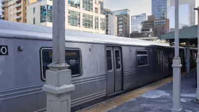
The Federal Transit Administration’s Pilot Program for Transit Oriented Development (TOD) Planning has awarded $13.1 million to 19 projects from around the nation that promote mixed-use development near transit stations, according to an article in Mass Transit.
“The program helps communities plan for opportunities created by new transit stations, such as affordable housing, economic development and better connections to schools, hospitals, stores and restaurants.”
The article quotes FTA Administrator Nuria Fernandez, who said, “When communities build new housing, retail, offices, and other construction near transit, they advance environmental justice and promote equity, particularly to underserved communities, by increasing access to opportunity and enabling and encouraging the creation and preservation of affordable housing.”
Awarded projects include a study of the Union Station/Civic Center Transit District in Los Angeles and a plan for TOD along Maryland’s Purple Line light rail project. See the source article for a link to the complete list of projects.
FULL STORY: FTA awards more than $13 million for transit-oriented development projects

How Federal Policy Can Encourage TOD
Tying transit and land acquisition funding together could help produce more housing near transit hubs.

Opinion: To Meet Climate Goals, Bay Area Needs More Transit-Oriented Development
The region's transit-oriented development (TOD) plan requires a significant update to achieve the density and housing goals laid out in the MTC's 30-year vision.

Opinion: California’s SB 79 Would Improve Housing Affordability and Transit Access
A proposed bill would legalize transit-oriented development statewide.

Rethinking Redlining
For decades we have blamed 100-year-old maps for the patterns of spatial racial inequity that persist in American cities today. An esteemed researcher says: we’ve got it all wrong.

Planetizen Federal Action Tracker
A weekly monitor of how Trump’s orders and actions are impacting planners and planning in America.

California High-Speed Rail's Plan to Right Itself
The railroad's new CEO thinks he can get the project back on track. The stars will need to align this summer.

US Senate Reverses California EV Mandate
The state planned to phase out the sale of gas-powered cars by 2035, a goal some carmakers deemed impossible to meet.

Trump Cuts Decimate Mapping Agency
The National Geodetic Survey maintains and updates critical spatial reference systems used extensively in both the public and private sectors.

Washington Passes First US ‘Shared Streets’ Law
Cities will be allowed to lower speed limits to 10 miles per hour and prioritize pedestrians on certain streets.
Urban Design for Planners 1: Software Tools
This six-course series explores essential urban design concepts using open source software and equips planners with the tools they need to participate fully in the urban design process.
Planning for Universal Design
Learn the tools for implementing Universal Design in planning regulations.
City of Camden Redevelopment Agency
City of Astoria
Transportation Research & Education Center (TREC) at Portland State University
Regional Transportation Commission of Southern Nevada
Toledo-Lucas County Plan Commissions