


Wildfire planning often focuses on individual buildings, but little guidance exists for effective citywide evacuation planning.
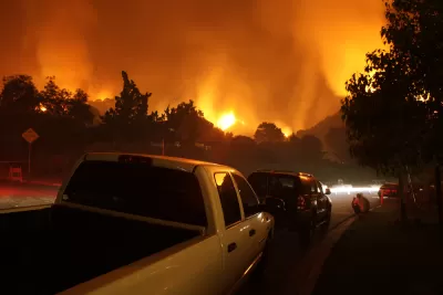
Increasingly powerful fires are devastating communities around the world, with tens of thousands of people already affected this year. “And yet, when it comes to things like planning evacuations, best practices don’t really exist—there’s no book to consult, no checklist to follow,” writes Caroline Mimbs Nyce in The Atlantic.
“The reason for this is that wildfire-evacuation research is still in its infancy,” Mimbs Nice explains. Although robust fire codes for buildings do exist, the same can’t be said for whole communities. Meanwhile, the unpredictable nature of fire makes it difficult to model predicted outcomes and establish protocols.
Mimbs Nyce outlines the challenges faced by authorities and residents during a fire: notification, time to meet with loved ones and get essentials, and transit time out of an affected area, which can be affected by road design, exit routes, and traffic. In addition to evacuation preparations, a town can also designate a highly protected gathering place as a refuge for people unable to flee.
Ali Mosleh, director of the B. John Garrick Institute for the Risk Sciences at UCLA, emphasizes the importance of developing standards catered to the needs of different types of communities. “They might need different numbers of evacuation routes, and different sorts of community-warning systems. Existing tools and simulations, like the one run on Camp Fire data, can help guide policy makers.”
FULL STORY: The World Needs to Start Planning for the Fire Age

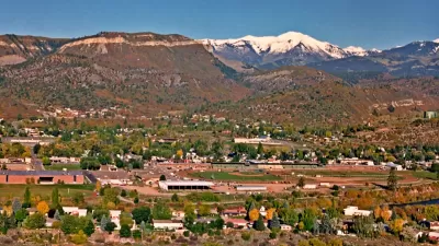
More Colorado Suburbs at Risk for Wildfires
Experts warn that more intense fires fueled by a warming climate are threatening an increasing number of Colorado's suburban communities.

Rebuilding Smarter: How LA County Is Guiding Fire-Ravaged Communities Toward Resilience
Los Angeles County is leading a coordinated effort to help fire-impacted communities rebuild with resilience by providing recovery resources, promoting fire-wise design, and aligning reconstruction with broader sustainability and climate goals.
Maui's Deadly Firestorm: Investigating the Tragedy and Lessons for the Future
FRONTLINE's Maui’s Deadly Firestorm investigates the 2023 Lahaina wildfire, uncovering critical failures in preparedness and response while examining the tragedy’s causes, impact, and lessons for future disaster prevention.

Maui's Vacation Rental Debate Turns Ugly
Verbal attacks, misinformation campaigns and fistfights plague a high-stakes debate to convert thousands of vacation rentals into long-term housing.

Planetizen Federal Action Tracker
A weekly monitor of how Trump’s orders and actions are impacting planners and planning in America.

San Francisco Suspends Traffic Calming Amidst Record Deaths
Citing “a challenging fiscal landscape,” the city will cease the program on the heels of 42 traffic deaths, including 24 pedestrians.

Defunct Pittsburgh Power Plant to Become Residential Tower
A decommissioned steam heat plant will be redeveloped into almost 100 affordable housing units.

Trump Prompts Restructuring of Transportation Research Board in “Unprecedented Overreach”
The TRB has eliminated more than half of its committees including those focused on climate, equity, and cities.

Amtrak Rolls Out New Orleans to Alabama “Mardi Gras” Train
The new service will operate morning and evening departures between Mobile and New Orleans.
Urban Design for Planners 1: Software Tools
This six-course series explores essential urban design concepts using open source software and equips planners with the tools they need to participate fully in the urban design process.
Planning for Universal Design
Learn the tools for implementing Universal Design in planning regulations.
Heyer Gruel & Associates PA
JM Goldson LLC
Custer County Colorado
City of Camden Redevelopment Agency
City of Astoria
Transportation Research & Education Center (TREC) at Portland State University
Jefferson Parish Government
Camden Redevelopment Agency
City of Claremont