


The city of Boston and Massachusetts Department of Transportation have applied to a $5 billion federal grant program aimed at ‘unusually large and complex projects.’
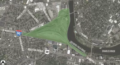
“On Tuesday, Mayor Michelle Wu and MassDOT submitted a grant application to Washington in hopes of winning $1.2 billion to build the Allston Multimodal Project, a massive reconfiguration of Interstate 90, Soldiers Field Road, and the Framingham/Worcester railroad line on 90 acres of land along the Charles River waterfront in Allston.” As Christiman MilNeil reports for Streetsblog Mass, the federal funding would match $754 million already committed by the city and state for the project.
According to the article, “the grant application promises that the new grid of streets that would create several new city blocks between the MBTA tracks and the riverfront will be built in accordance with the city’s and the state’s ‘complete streets’ design guidelines, with ‘extensive bicycle and pedestrian infrastructure.’” Despite this, “the latest conceptual sketches of the project still show that many of those streets will be unusually wide by Boston’s standards, with five or more lanes for motor vehicle traffic.”
MilNeil writes that “A statement from the mayor’s office also hints that the city will be looking for significant affordable housing commitments from the private development that’s expected to occur on those new city blocks, which are owned by Harvard University.” In a press statement, Boston Mayor Michelle said that “By prioritizing access to the riverfront, public transit routes, and added space for affordable housing, we can ensure we’re making the right decisions for future generations of Boston residents and visitors.”
Environmental impact reviews for the project, expected to be completed by the end of 2021, will likely not be ready until 2025. If the federal funding is approved, “Construction could then begin in the fall of that year, and last 7 years to complete the project by fall 2032.”
FULL STORY: Boston, MassDOT Seek ‘Mega’ Cash to Build Allston/I-90 Project

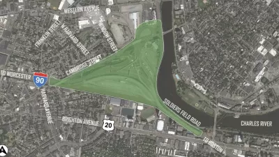
Should This Mass Pike Viaduct Come Down?
Public opinion favors an at-grade highway, but the state is still considering retaining the elevated section in Allston.

Op-Ed: Postponing Transit in Allston Will Cost Boston
As the state plans a major renovation to the Massachusetts Turnpike, whether an Allston transit hub is built or delayed may determine how effectively the surrounding neighborhood develops.
Super Sharrows: "Feel of a Bike Lane" or Wasted Paint?
New "sharrows on steroids" are being tested In the Allston neighborhood of Boston. Are the markings - parallel dashed lines bracketing a bicycle icon - a legitimate improvement on the controversial practice or "an underwhelming innovation"?

Maui's Vacation Rental Debate Turns Ugly
Verbal attacks, misinformation campaigns and fistfights plague a high-stakes debate to convert thousands of vacation rentals into long-term housing.

Planetizen Federal Action Tracker
A weekly monitor of how Trump’s orders and actions are impacting planners and planning in America.

Chicago’s Ghost Rails
Just beneath the surface of the modern city lie the remnants of its expansive early 20th-century streetcar system.

Bend, Oregon Zoning Reforms Prioritize Small-Scale Housing
The city altered its zoning code to allow multi-family housing and eliminated parking mandates citywide.

Amtrak Cutting Jobs, Funding to High-Speed Rail
The agency plans to cut 10 percent of its workforce and has confirmed it will not fund new high-speed rail projects.

LA Denies Basic Services to Unhoused Residents
The city has repeatedly failed to respond to requests for trash pickup at encampment sites, and eliminated a program that provided mobile showers and toilets.
Urban Design for Planners 1: Software Tools
This six-course series explores essential urban design concepts using open source software and equips planners with the tools they need to participate fully in the urban design process.
Planning for Universal Design
Learn the tools for implementing Universal Design in planning regulations.
planning NEXT
Appalachian Highlands Housing Partners
Mpact (founded as Rail~Volution)
City of Camden Redevelopment Agency
City of Astoria
City of Portland
City of Laramie