The largest infrastructure project in D.C. history is opening this week—first to pedestrians and then to automobile traffic.


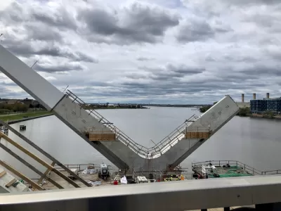
Luz Lazo and Michael Laris report on the debut of the new Frederick Douglass Memorial Bridge, which opened to the public on September 6 and replaced a 71-year-old bridge spanning the Anacostia River in Washington, D.C.
The new bridge is 1,445 feet long and cost $480 million—that latter figure making the new bridge the largest infrastructure project in the history of the District.
"The bridge is not finished. Vises hold up 2-by-4s as makeshift barriers on concrete lookout areas, and paving and connections aren’t complete on wide pedestrian pathways. But Monday’s bridge celebration — starting with a 5K run and walk led by Mayor Muriel E. Bowser — offered expansive views and the chance for many to consider a changing city," according to the article.
Vehicle traffic is expected to start crossing the bridge on Friday and Saturday of this week. "Runners, walkers and stroller-pushers began crossing the span about 9 a.m. Monday as an American flag waved from one of its towering white arches."
The article includes anecdotes and soundbites from the bridges debut on Labor Day. Lazo and Laris also sum up the relevance of the bridge's reopening relative to the larger cultural context and planning history of the District thusly:
The opening of the distinct structure with parallel arcs marks a milestone in the vision to turn the South Capitol Street Corridor into the grand boulevard that Pierre L’Enfant envisioned in his original plan for the nation’s capital. L’Enfant identified the corridor as a symbolic gateway into the District’s monumental core, one that has not been realized as the road maintained a freeway-type configuration that lacked adequate pedestrian and cycling facilities.
FULL STORY: New $480 million Frederick Douglass Memorial Bridge begins opening week with a Labor Day celebration

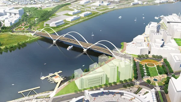
Iconic New Bridge Project Revealed in D.C.
The new Frederick Douglass Memorial Bridge will span the Anacostia River between Washington, D.C. and Anacostia.
Federal agencies give go-ahead to I-5 Columbia River bridge project
The next few months will clarify whether the massive bridge replacement project will secure the funding to move forward as planned.

Now you can cross from Iowa to South Dakota on a pedestrian bridge
The Big Sioux Pedestrian Bridge connects a park and a golf course on the other side of the Big Sioux River.

The state-sanctioned urbicide of Austin
People don’t kill cities. Freeways do.

US to reduce Colorado River water deliveries to Mexico
A new Colorado Treaty amendment reduces Mexico’s Colorado River water allocation by 250,000 acre feet.

New Jersey’s second-largest city bans standalone data centers
Jersey City will continue to allow co-location facilities, such as those meant for research institutions that store their own data.

Amtrak not solely to blame for New Jersey commuter rail's unreliability, report finds
A new study from the Garden State Initiative found that NJ Transit’s budget grew 20% across a 4 year period, but reliability declined significantly over the same period.

EPA erases limits on planet-warming pollution from power plants
Under Monday’s plan, power plants would still have some limits on how much mercury, arsenic and other contaminants they can emit.

Phoenix announces new on-demand transit service, more frequent RAPID buses
Both new services will launch in October, and are part of Phoenix's Project Effective Access Solutions for Easing Congestion.

FREE Course: Walkable City 1: Why Walkability?
After describing his path towards focusing on walkability as the essence of good planning, Jeff Speck marches through his five principal reasons for making more walkable places.
Reinventing Malls: Planning Alchemy—Turning Gray Fields Into Gold
The course focuses on the opportunities and imperatives that shape reinvention of mall sites.

Eagle County Government
Harvard University Graduate School of Design
Nashville Planning Department
The Architects Foundation
University of Cincinnati Online
The Pocatello Development Authority
The Urban Renewal Agency of the City of Pocatello
Journal of the American Planning Association