


The Annenberg Foundation is awarding a $25 million grant to the National Wildlife Federation's campaign to build a wildlife crossing at Liberty Canyon, over the 101 Freeway.
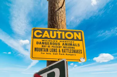
Wildlife in the Santa Monica Mountains faces a major problem. With freeways surrounding and bisecting the wild spaces, migration to and from the mountains is difficult and can even be deadly. Migration is needed to maintain genetic diversity, without which populations move toward local extinction. But there is a proposed solution for a significant barrier to genetic diversity: a wildlife bridge over the 101 Freeway.
The Wildlife Crossing at Liberty Canyon is a collaboration between the National Wildlife Federation, the National Park Service, Caltrans, the Santa Monica Mountains Conservancy, and the Resource Conservation District of the Santa Monica Mountains. The project will not be cheap, with an estimated price tag of about $87 million. However, as reported by Michael Wittner, a significant infusion of funds is moving the project closer to reality. Specifically, the Annenberg Foundation is awarding a $25 million grant to help with the creation of the wildlife crossing which will span ten lanes of highway and pavement and will be covered in nearly an acre of native vegetation.
For more information, please read the source article.
FULL STORY: Liberty Canyon Crossing Gets $25M Challenge Grant From Annenberg


California Wildlife Crossings Get New Funding
The state is budgeting $61 million to build wildlife crossings that increase biodiversity, help species thrive, and save both human and animal lives.
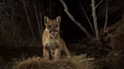
The Best Locations for L.A.’s Mountain Lion Freeway Bridges
A coalition of researchers have identified one area near the 101 and other near I-15 that would help keep the big cats alive and healthy.
Wildlife Rebounds After the Eaton Fire
Following the devastation of the Eaton Fire, the return of wildlife and the regrowth of native plants are offering powerful signs of resilience and renewal.

Montreal Mall to Become 6,000 Housing Units
Place Versailles will be transformed into a mixed-use complex over the next 25 years.

Planetizen Federal Action Tracker
A weekly monitor of how Trump’s orders and actions are impacting planners and planning in America.

DARTSpace Platform Streamlines Dallas TOD Application Process
The Dallas transit agency hopes a shorter permitting timeline will boost transit-oriented development around rail stations.

Study: 4% of Truckers Lack a Valid Commercial License
Over 56% of inspected trucks had other violations.

Chicago Judge Orders Thousands of Accessible Ped Signals
Only 3% of the city's crossing signals are currently accessible to blind pedestrians.

Philadelphia Swaps Car Lanes for Bikeways in Unanimous Vote
The project will transform one of the handful of streets responsible for 80% of the city’s major crashes.
Urban Design for Planners 1: Software Tools
This six-course series explores essential urban design concepts using open source software and equips planners with the tools they need to participate fully in the urban design process.
Planning for Universal Design
Learn the tools for implementing Universal Design in planning regulations.
City of Mt Shasta
City of Camden Redevelopment Agency
City of Astoria
Transportation Research & Education Center (TREC) at Portland State University
US High Speed Rail Association
City of Camden Redevelopment Agency
Municipality of Princeton (NJ)