


The Connect Dallas Strategic Mobility Plan is open for public comment. Expect more big plans from Dallas soon—the ForwardDallas! comprehensive plan update will also kick off this year.
The city of Dallas recently released the draft of its first-ever five-year Strategic Mobility Plan, Connect Dallas. The draft culminates two years of work by city officials, the Dallas Department of Transportation, residents, and stakeholders.
According to the draft document [pdf], Connect Dallas is intended to further the city's sustainability, safety, equity, housing, and economic goals.
The following are among the specific measures targeted by the plan include new support for transit initiatives and new attention to the connections between transportation outcomes and land use regulations:
- Reform the development review process to support multi-modal transportation by right-sizing parking requirements, shifting impact analysis from Level of Service to Vehicle Miles Traveled, among other actions.
- Streamline project delivery processes for all transportation programs, like the bike program, vision zero, and ADA conformity.
- Create a Transit Support Program to coordinate with various city of Dallas departments to help streamline coordination on transit initiatives, and advance improvements to transit speed, reliability, and access.
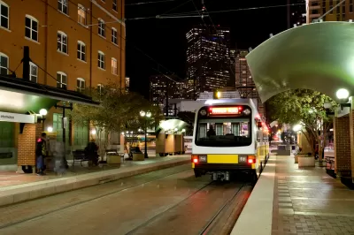
- Establish a citywide Mobility Hub framework to enhance access to existing transit service and identify capital investment needs to support increasing transit ridership.
- Update the Thoroughfare Plan and the Bike Plan to identify existing roadway and bicycle facility needs.
- Adopt a Vision Zero Action plan.
- Develop a freight master plan that updates designated truck routes based on changes to land use, sets policy on the design of roadways along truck routes and where truck routes intersect with pedestrian and bicycle routes, and identifies future infrastructure investments and improvements needed to support efficient freight movement, increase safety, and address freight-related issues.
- Create a Mobility Management Working Group within the Department of Transportation to begin to manage the city's curbside mobility assets.
- Implement a staff-wide transportation demand management system for city employees as a model for external replication.
One of the document's driving principles is to align the city's land use goals, set to be revised in the city's ForwardDallas! comprehensive plan update, underway in 2021 and 2022. ForwardDallas! was last updated in 2006.
The 100-page draft plan is open for public comment until February 5, 2021.
FULL STORY: Connect Dallas Strategic Mobility Plan


Dallas Launches New Comprehensive Plan Process—15 Years After ForwardDallas
The city of Dallas adopted the ForwardDallas plan in 2006, setting a grand ambition for a more walkable, transit-friendly city. Some of the work toward that vision will have to continue with the next comprehensive plan.

Development Code, Future Land Use Map Updates Coming to Dallas
The ForwardDallas initiative is attempting for the Holy Grail of planning: development certainty.
Uproar Over 'Surprise' Big Box Development in Dallas
The evolving story goes back to last summer, but media and stakeholders were caught off guard by the recent revelation that Trammell Crow Co. is planning to develop a 100,00 square foot Sam's Club in Dallas.

Montreal Mall to Become 6,000 Housing Units
Place Versailles will be transformed into a mixed-use complex over the next 25 years.

Planetizen Federal Action Tracker
A weekly monitor of how Trump’s orders and actions are impacting planners and planning in America.

DARTSpace Platform Streamlines Dallas TOD Application Process
The Dallas transit agency hopes a shorter permitting timeline will boost transit-oriented development around rail stations.

Study: 4% of Truckers Lack a Valid Commercial License
Over 56% of inspected trucks had other violations.

Chicago Judge Orders Thousands of Accessible Ped Signals
Only 3% of the city's crossing signals are currently accessible to blind pedestrians.

Philadelphia Swaps Car Lanes for Bikeways in Unanimous Vote
The project will transform one of the handful of streets responsible for 80% of the city’s major crashes.
Urban Design for Planners 1: Software Tools
This six-course series explores essential urban design concepts using open source software and equips planners with the tools they need to participate fully in the urban design process.
Planning for Universal Design
Learn the tools for implementing Universal Design in planning regulations.
City of Mt Shasta
City of Camden Redevelopment Agency
City of Astoria
Transportation Research & Education Center (TREC) at Portland State University
US High Speed Rail Association
City of Camden Redevelopment Agency
Municipality of Princeton (NJ)