


Huge amounts of land are dedicated to asphalt in Kansas City—about twice as much land than is dedicated to buildings. Fiscal dependence on vehicular infrastructure, however, is not unique to Kansas City.

Daniel Herriges' recent Strong Towns article is a part of a longer-term series about the history of Kansas City, Missouri, and the relationship between its development and economy. Up for discussion: "total embrace of the automotive, commuter culture wrought upon the city's historic fabric. And that is parking," writes Herriges.
An animated map of the land uses of Kansas City shows the extent to which parking has taken over large swaths of public space. As planners know well, parking mandates the silent and seemingly invisible force shaping cities and determining lot size and building type.
Prominent in the map are large red arrows pointing to parking structures. Herriges explains the reason for the gargantuan amount of surface parking in downtown Kansas City, describing the lack of demand for downtown real estate as the suburbs became popular in the late 20th century:
If you wanted to speculate on some downtown Kansas City land by buying it when it was cheap and waiting—even for decades—to sell to a developer, slapping a parking lot on that land was an easy way to make a bit of income in the interim. This pattern exists across North America: many of these lots are privately owned and, while they may bring in more than enough revenue to pay the low property taxes on unimproved asphalt, the point isn't really the parking operation. The point is land speculation.
There is more land dedicated to concrete and parking than buildings in Kansas City—over twice as much. Herriges says we need to look at data to identify inefficiencies and understand the fiscal impact of haphazard development.
FULL STORY: Asphalt City: How Parking Ate an American Metropolis

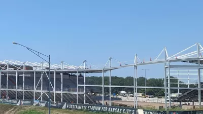
New Kansas City Stadium Offers Limited Parking
Unlike many sports arenas surrounded by seas of concrete, the new CPKC Stadium has parking for just 2,000 vehicles, hoping most sports fans will arrive by transit.

Watch: How to Remove Thousands of Parking Spaces
What the city of Amsterdam will gain by removing cars from on-street parking space.
Will ‘Worst Parking Crater’ Award Produce Policy Change?
Streetsblog doesn’t pull any punches with its “Golden Crater” award—an award for the worst parking crater in the country, selected by a March Madness style tournament. This year's winner/loser: Rochester, New York.

Maui's Vacation Rental Debate Turns Ugly
Verbal attacks, misinformation campaigns and fistfights plague a high-stakes debate to convert thousands of vacation rentals into long-term housing.

Planetizen Federal Action Tracker
A weekly monitor of how Trump’s orders and actions are impacting planners and planning in America.

In Urban Planning, AI Prompting Could be the New Design Thinking
Creativity has long been key to great urban design. What if we see AI as our new creative partner?

Cal Fire Chatbot Fails to Answer Basic Questions
An AI chatbot designed to provide information about wildfires can’t answer questions about evacuation orders, among other problems.

What Happens if Trump Kills Section 8?
The Trump admin aims to slash federal rental aid by nearly half and shift distribution to states. Experts warn this could spike homelessness and destabilize communities nationwide.

Sean Duffy Targets Rainbow Crosswalks in Road Safety Efforts
Despite evidence that colorful crosswalks actually improve intersection safety — and the lack of almost any crosswalks at all on the nation’s most dangerous arterial roads — U.S. Transportation Secretary Duffy is calling on states to remove them.
Urban Design for Planners 1: Software Tools
This six-course series explores essential urban design concepts using open source software and equips planners with the tools they need to participate fully in the urban design process.
Planning for Universal Design
Learn the tools for implementing Universal Design in planning regulations.
Appalachian Highlands Housing Partners
Gallatin County Department of Planning & Community Development
Heyer Gruel & Associates PA
Mpact (founded as Rail~Volution)
City of Camden Redevelopment Agency
City of Astoria
City of Portland
City of Laramie