


Google's Environmental Insights Explorer multiplies the power of Google Maps for the benefit of the planet.

"Looking at a city’s Google Maps data, in combination with other data, a new tool from Google can estimate the carbon footprint of all of its buildings–and the carbon footprint of all the car trips, bus and subway rides, and other transportation used by the people living there," reports Adele Peters.
The new tool, called the Environmental Insights Explorer, launched in beta on September 10, and designed to help cities account for carbon emissions—accounting being an initial step before reductions can be made. The accounting process can be labor intensive and expensive—now Google has covered a large portion of the expense, free of cost.
FULL STORY: A new use for Google Maps: calculating a city’s carbon footprint


One U.S. State Boasts 33% Fewer Carbon Emissions Per Capita Than Any Other
California, the largest state by population in the United States, is responsible for 33% fewer carbon emissions per capita than any other state, according to a new study published in the Proceedings of the National Academy of Sciences.
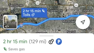
Google Maps Feature Identifies Most Fuel-Efficient Routes
A new feature highlights routes that use the least gas to help users make the most fuel-efficient driving decisions.
Mapping Climate Impact at the Neighborhood Level
A consumption-based analysis illustrates the differences in average household emissions across census tracts.

Montreal Mall to Become 6,000 Housing Units
Place Versailles will be transformed into a mixed-use complex over the next 25 years.

Planetizen Federal Action Tracker
A weekly monitor of how Trump’s orders and actions are impacting planners and planning in America.

DARTSpace Platform Streamlines Dallas TOD Application Process
The Dallas transit agency hopes a shorter permitting timeline will boost transit-oriented development around rail stations.

Study: 4% of Truckers Lack a Valid Commercial License
Over 56% of inspected trucks had other violations.

Chicago Judge Orders Thousands of Accessible Ped Signals
Only 3% of the city's crossing signals are currently accessible to blind pedestrians.

Philadelphia Swaps Car Lanes for Bikeways in Unanimous Vote
The project will transform one of the handful of streets responsible for 80% of the city’s major crashes.
Urban Design for Planners 1: Software Tools
This six-course series explores essential urban design concepts using open source software and equips planners with the tools they need to participate fully in the urban design process.
Planning for Universal Design
Learn the tools for implementing Universal Design in planning regulations.
City of Mt Shasta
City of Camden Redevelopment Agency
City of Astoria
Transportation Research & Education Center (TREC) at Portland State University
US High Speed Rail Association
City of Camden Redevelopment Agency
Municipality of Princeton (NJ)