


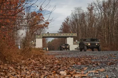
The National Guard at Fort Indiantown Gap uses GIS technology and land management strategies to balance military training with conservation efforts, ensuring the survival of the rare eastern regal fritillary butterfly.
At Pennsylvania’s Fort Indiantown Gap National Guard Training Center, thousands of soldiers train annually in live-fire exercises, yet the base also serves as the last natural home of the eastern regal fritillary butterfly. Rather than relocating military activities, conservationists and military land managers have embraced the disturbances caused by training exercises as essential to the butterfly’s survival. Using Geographic Information System (GIS) technology, biologists track butterfly populations, analyze habitat conditions, and implement land management strategies such as prescribed burns, mowing, and planting violets—the butterfly’s primary host plant. The controlled environmental disruptions help maintain the open grasslands required for the species to thrive, preventing reforestation that would otherwise eliminate its habitat.
As reported by Chris Oxendine and Sunny Fleming, the National Guard has been actively managing the butterfly’s habitat since 1992, using GIS-powered tools to map vegetation, track species populations, and plan conservation efforts. The partnership between Fort Indiantown Gap, the U.S. Fish and Wildlife Service (FWS), and state conservation agencies has been crucial in monitoring and expanding habitat availability. The violet plant, critical for caterpillar survival, flourishes in areas with frequent disturbances from both training activities and prescribed burns. Conservationists have also developed new butterfly reintroduction sites in Pennsylvania, using GIS apps like ArcGIS Survey123 to engage students and volunteers in tracking population changes and nectar sources.
Despite these efforts, the eastern regal fritillary butterfly remains at risk, with the FWS recently proposing to add it to the endangered species list. Conservationists continue refining their strategies, leveraging GIS to adapt and enhance conservation initiatives in real time. Data-sharing across organizations enables scientists to monitor conditions at multiple sites without delays, improving decision-making and habitat management. The ongoing efforts at Fort Indiantown Gap demonstrate how military training and ecological preservation can coexist, using technology and strategic land management to protect a fragile species in an unlikely setting.
FULL STORY: Butterflies and Bombs: How the National Guard Plays a Vital Role in Species Conservation


Nevada and Utah Groups Oppose Public Land Sell-Off Plan
A set of last-minute amendments to the budget reconciliation bill open up over half a million acres of federally managed land to sales.

New Trail Project Enhances Safety and Access to Rocky Flats National Wildlife Refuge
Jefferson County is improving safe access to Rocky Flats National Wildlife Refuge with new trails, a bridge, and signage, as part of the Rocky Mountain Greenway project, ensuring environmental safety and educating visitors about the site’s history.

Creating Ocean-Safe Plastic from Seashells
USC researchers have created a biodegradable, marine-safe plastic alternative using calcium carbonate from seashells, offering a promising solution to ocean pollution.

Planetizen Federal Action Tracker
A weekly monitor of how Trump’s orders and actions are impacting planners and planning in America.

Chicago’s Ghost Rails
Just beneath the surface of the modern city lie the remnants of its expansive early 20th-century streetcar system.

San Antonio and Austin are Fusing Into one Massive Megaregion
The region spanning the two central Texas cities is growing fast, posing challenges for local infrastructure and water supplies.

Since Zion's Shuttles Went Electric “The Smog is Gone”
Visitors to Zion National Park can enjoy the canyon via the nation’s first fully electric park shuttle system.

Trump Distributing DOT Safety Funds at 1/10 Rate of Biden
Funds for Safe Streets and other transportation safety and equity programs are being held up by administrative reviews and conflicts with the Trump administration’s priorities.

German Cities Subsidize Taxis for Women Amid Wave of Violence
Free or low-cost taxi rides can help women navigate cities more safely, but critics say the programs don't address the root causes of violence against women.
Urban Design for Planners 1: Software Tools
This six-course series explores essential urban design concepts using open source software and equips planners with the tools they need to participate fully in the urban design process.
Planning for Universal Design
Learn the tools for implementing Universal Design in planning regulations.
planning NEXT
Appalachian Highlands Housing Partners
Mpact (founded as Rail~Volution)
City of Camden Redevelopment Agency
City of Astoria
City of Portland
City of Laramie