


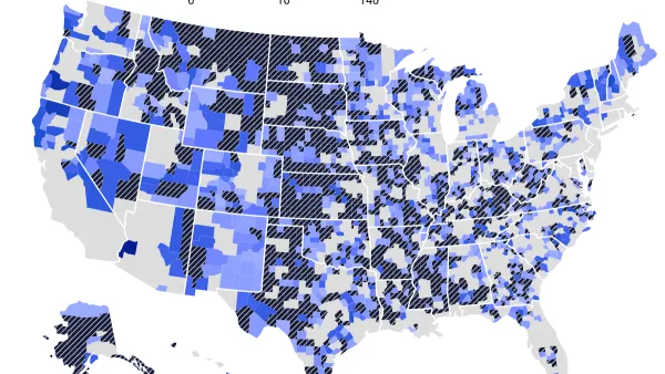
The federal tool used to inform flood protection spending calculates communities' risk by multiplying expected annual loss in dollars by their risk factor. As a result, many rural areas are classified as “low” risk, despite frequent, severe flooding.
Daily Yonder, in a collaboration with Climate Central, published an article highlighting the “bias” in FEMA’s disaster assistance calculations, which it says could prevent rural regions from benefiting from flood mitigation projects funded by the Bipartisan Infrastructure Bill and future federal infrastructure funding. “FEMA developed its National Risk Index to help local and state officials and residents plan for emergencies through an online tool,” write authors Claire Carlson and Elizabeth Miller. The tool uses historic rainfall and other data to characterize risk and inform its spending decisions. The problem? Many rural communities, even those that have suffered from natural disasters like major flooding in the past, are still classified as “low” risk by the tool, “largely because they have less to lose — financially — compared to more urbanized areas,” according to the article.
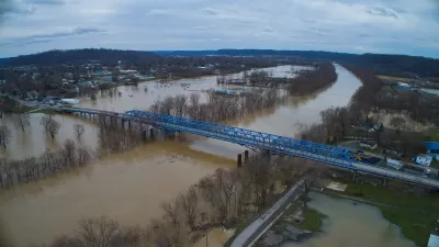
The article offers in-depth examples of how this “bias” has played out in Eastern Kentucky, which floods on a regular basis but experienced a catastrophic flooding event two years ago. Despite this fact, FEMA’s National Risk Index classifies the 13 counties declared federal disaster areas two years ago as facing “low” or “very low” risks. That’s because the “National Risk Index multiplies a community’s expected annual loss in dollars by their risk factor,” according to the article, and the median household income and home values in those rural counties is significantly lower, in some cases up to half, of the national average.
“This urban-rural difference matters because FEMA uses the National Risk Index to determine how much money communities should receive to better prepare for natural disasters” the article reads.
Chad Berginnis, executive director of the Association of State Floodplain Managers, also told Daily Yonder and Climate Central: “There’s a bias against, I think, rural communities, especially in the flood dataset,” which he said could “profoundly” confuse or affect emergency managers in those areas. That tool is also “being used to make decisions about spending $1.2 trillion available to lessen future flood risks under the U.S. Infrastructure Investment and Jobs Act,” Carlson and Miller write, which could lead to underinvestment in rural communities.
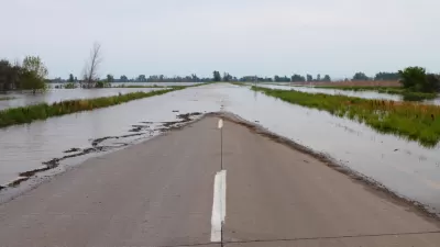
This is also an important issue in the context of the housing affordability crisis. There is an urgency to build new, affordable housing units, but the cheapest and most readily available land to build on also tends to be the land most vulnerable to flooding and other hazards. Without accurate and unbiased data and risk calculation, there is a potential that a lot of that new housing could end up in areas that are at high-risk for climate-related disasters.
FULL STORY: The Rural Americans Too Poor for Federal Flood Protections

FEMA Extends Deadline for Hazard Mitigation Grant Applications
Tight applications prevented many communities struck by disasters from applying for FEMA resilience grants, so the agency issued a new rule that extended the application window.
The EV “Charging Divide” Plaguing Rural America
With “the deck stacked” against rural areas, will the great electric American road trip ever be a reality?
‘Quality Work, Fast’: NC Gears up for Homebuilding After Helene, Trying to Avoid Past Pitfalls
The state will field bids to demolish, repair and rebuild homes in the mountains. After struggles in eastern NC, officials aim to chart a different course.

Maui's Vacation Rental Debate Turns Ugly
Verbal attacks, misinformation campaigns and fistfights plague a high-stakes debate to convert thousands of vacation rentals into long-term housing.

Planetizen Federal Action Tracker
A weekly monitor of how Trump’s orders and actions are impacting planners and planning in America.

Chicago’s Ghost Rails
Just beneath the surface of the modern city lie the remnants of its expansive early 20th-century streetcar system.

Bend, Oregon Zoning Reforms Prioritize Small-Scale Housing
The city altered its zoning code to allow multi-family housing and eliminated parking mandates citywide.

Amtrak Cutting Jobs, Funding to High-Speed Rail
The agency plans to cut 10 percent of its workforce and has confirmed it will not fund new high-speed rail projects.

LA Denies Basic Services to Unhoused Residents
The city has repeatedly failed to respond to requests for trash pickup at encampment sites, and eliminated a program that provided mobile showers and toilets.
Urban Design for Planners 1: Software Tools
This six-course series explores essential urban design concepts using open source software and equips planners with the tools they need to participate fully in the urban design process.
Planning for Universal Design
Learn the tools for implementing Universal Design in planning regulations.
planning NEXT
Appalachian Highlands Housing Partners
Mpact (founded as Rail~Volution)
City of Camden Redevelopment Agency
City of Astoria
City of Portland
City of Laramie