


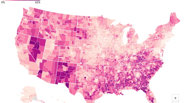
The California Healthy Places Index: Extreme Heat Edition is a tool which provides datasets on projected heat exposure for California, including place-based indicators measuring community conditions and sensitive populations.

The Healthy Places Index (HPI), a resource developed by the Public Health Alliance of Southern California, is well-known as a powerful tool that can be used to explore community conditions that predict life expectancy, compare and rank scores at multiple California geographies, and learn about concrete and actionable policy solutions.
There is now the Extreme Heat Edition of the HPI which is developed by the Public Health Alliance in partnership with the UCLA Luskin Center for Innovation. This new tool provides datasets on projected heat exposure for California, including place-based indicators measuring community conditions and sensitive populations. It also provides a list of resources and funding opportunities that can be used to address extreme heat.
Specifically, the tool can be used to:
- Understand underlying heat vulnerability and resilience characteristics of a community
- Identify resources to mitigate adverse effects of extreme heat
- Prioritize public and private investments, resources and programs
To learn more about the methodology and capabilities of the HPI: Extreme Heat Edition, please review the technical report.
FULL STORY: New Online Mapping Tool Helps California Prepare for Extreme Heat


Aging NYC Subway Cars No Match for Extreme Heat
The MTA receives thousands of complaints about broken air conditioning on subway cars each summer.
Data: In Rural America, Mobile Homes are Heat Traps
Extreme heat is often viewed as an urban problem, but rural communities face their own unique risks.
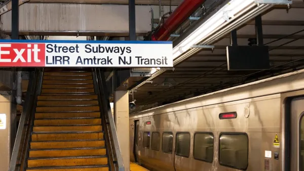
NJ Transit Trains Delayed by Extreme Heat
Breakdowns in the subway network’s HVAC system caused dangerously high temperatures on platforms, while heat-induced track expansion forced trains to slow down.

Maui's Vacation Rental Debate Turns Ugly
Verbal attacks, misinformation campaigns and fistfights plague a high-stakes debate to convert thousands of vacation rentals into long-term housing.

Planetizen Federal Action Tracker
A weekly monitor of how Trump’s orders and actions are impacting planners and planning in America.

In Urban Planning, AI Prompting Could be the New Design Thinking
Creativity has long been key to great urban design. What if we see AI as our new creative partner?

King County Supportive Housing Program Offers Hope for Unhoused Residents
The county is taking a ‘Housing First’ approach that prioritizes getting people into housing, then offering wraparound supportive services.

Researchers Use AI to Get Clearer Picture of US Housing
Analysts are using artificial intelligence to supercharge their research by allowing them to comb through data faster. Though these AI tools can be error prone, they save time and housing researchers are optimistic about the future.

Making Shared Micromobility More Inclusive
Cities and shared mobility system operators can do more to include people with disabilities in planning and operations, per a new report.
Urban Design for Planners 1: Software Tools
This six-course series explores essential urban design concepts using open source software and equips planners with the tools they need to participate fully in the urban design process.
Planning for Universal Design
Learn the tools for implementing Universal Design in planning regulations.
planning NEXT
Appalachian Highlands Housing Partners
Mpact (founded as Rail~Volution)
City of Camden Redevelopment Agency
City of Astoria
City of Portland
City of Laramie