


National Park officials are asking for the public's help to track down those responsible for graffiti recently painted in the park.
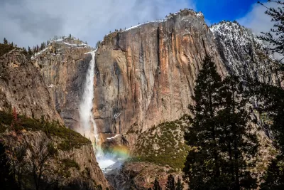
Yosemite National Park is one the most well-known national parks in the United States. The park, which covers an area of 759,620 acres and was designated a World Heritage Site in 1984, is internationally recognized for its granite cliffs, waterfalls, clear streams, giant sequoia groves, lakes, mountains, meadows, glaciers, and biological diversity. Yosemite is one of the largest and least fragmented habitat blocks in the Sierra Nevada, supporting a wide variety of plants and animals.
Unfortunately, park rangers recently discovered about 30 areas of graffiti sprayed painted along the Yosemite Falls Trail. In photos shared by the National Park Service (NPS), rocks were shown damaged with blue and white spray paint. The graffiti ranged in size from one foot by one foot to as large as eight feet by eight feet. NPS is asking for help from the public to track down the individual or individuals behind responsible for the damage.
For more information, please read the source article by Amanda Jackson and Lilit Marcus of CNN.
FULL STORY: Yosemite National Park asks for public help finding people behind graffiti vandalism


Graffiti Covering NYC Subway Trains Again
Grafitti is making a comeback on the New York Subway.

Graffiti Wins Protected Legal Status in New York
A landmark judgement potentially paves the way for graffiti to be protected under the Visual Artists Rights Act.
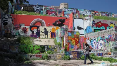
Death Warrant Signed for Austin's Graffiti Park
The Hope Outdoor Galley, as Graffiti Park is officially known, will relocate to a decidedly less central location.

Planetizen Federal Action Tracker
A weekly monitor of how Trump’s orders and actions are impacting planners and planning in America.

Maui's Vacation Rental Debate Turns Ugly
Verbal attacks, misinformation campaigns and fistfights plague a high-stakes debate to convert thousands of vacation rentals into long-term housing.

San Francisco Suspends Traffic Calming Amidst Record Deaths
Citing “a challenging fiscal landscape,” the city will cease the program on the heels of 42 traffic deaths, including 24 pedestrians.

Amtrak Rolls Out New Orleans to Alabama “Mardi Gras” Train
The new service will operate morning and evening departures between Mobile and New Orleans.

The Subversive Car-Free Guide to Trump's Great American Road Trip
Car-free ways to access Chicagoland’s best tourist attractions.

San Antonio and Austin are Fusing Into one Massive Megaregion
The region spanning the two central Texas cities is growing fast, posing challenges for local infrastructure and water supplies.
Urban Design for Planners 1: Software Tools
This six-course series explores essential urban design concepts using open source software and equips planners with the tools they need to participate fully in the urban design process.
Planning for Universal Design
Learn the tools for implementing Universal Design in planning regulations.
Heyer Gruel & Associates PA
JM Goldson LLC
Custer County Colorado
City of Camden Redevelopment Agency
City of Astoria
Transportation Research & Education Center (TREC) at Portland State University
Jefferson Parish Government
Camden Redevelopment Agency
City of Claremont