


One of the fastest-growing cities in the country could be making space for even more growth.
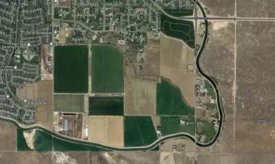
Margaret Carmel reports on the initial public hearings for the Murio Farms development, which would be located on a 380-acre parcel in Southwest Boise.
"The property, which was a dairy operated by the Murgoitio family for generations, is located near the New York Canal between Maple Grove and Cole Roads," according to Carmel.
"If the application is successful, it could include 3,560 housing units, 246,000 square feet of commercial space, an elementary school, and a network of paths and open space by 2040. The density of the lots will vary from block to block, ranging from traditional single-family homes on large lots to mixed-use blocks with apartments on top of commercial spaces."
A team of developers is planning to create a specific plan for the site. According to Carmel, "This unique style of zoning allows a developer to create a planned community with customizable zoning requirements that is approved all at once, although it is built in phases. It requires the developer to submit a high level of detail upfront, including a transportation plan, landscape concepts, dimensional standards, prototypes for specific blocks, and a detailed map of pathways and roads."
The article digs into the traffic study—already under review by the Ada County Highway District—connected to the development proposal, as well as questions about infrastructure, like adding fire department capacity and new parks.
FULL STORY: Boise gears up for proposal to build 3,500+ homes: traffic, fire, parks all early questions

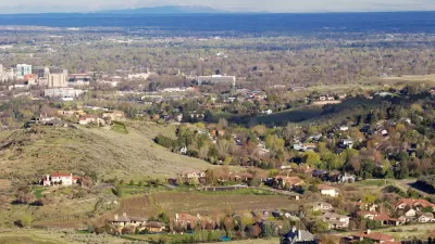
Different Approaches to Fast Growth in Idaho's Treasure Valley
Three cities on the periphery of the fast-growing Treasure Valley showcase different approaches to a sudden influx of newcomers.
Why California Should Not, Cannot Solve Its Housing Crisis By Building New Cities
A recent essay advocates for the development of a new city in California to alleviate the state's housing crisis. The argument needs a few tweaks.

The Potential of New Towns
Richard Peiser and Ann Forsyth discuss their latest book, New Towns for the Twenty-First Century: A Guide to Planned Communities Worldwide, with the Penn Institute for Urban Research.

Maui's Vacation Rental Debate Turns Ugly
Verbal attacks, misinformation campaigns and fistfights plague a high-stakes debate to convert thousands of vacation rentals into long-term housing.

Planetizen Federal Action Tracker
A weekly monitor of how Trump’s orders and actions are impacting planners and planning in America.

In Urban Planning, AI Prompting Could be the New Design Thinking
Creativity has long been key to great urban design. What if we see AI as our new creative partner?

King County Supportive Housing Program Offers Hope for Unhoused Residents
The county is taking a ‘Housing First’ approach that prioritizes getting people into housing, then offering wraparound supportive services.

Researchers Use AI to Get Clearer Picture of US Housing
Analysts are using artificial intelligence to supercharge their research by allowing them to comb through data faster. Though these AI tools can be error prone, they save time and housing researchers are optimistic about the future.

Making Shared Micromobility More Inclusive
Cities and shared mobility system operators can do more to include people with disabilities in planning and operations, per a new report.
Urban Design for Planners 1: Software Tools
This six-course series explores essential urban design concepts using open source software and equips planners with the tools they need to participate fully in the urban design process.
Planning for Universal Design
Learn the tools for implementing Universal Design in planning regulations.
planning NEXT
Appalachian Highlands Housing Partners
Mpact (founded as Rail~Volution)
City of Camden Redevelopment Agency
City of Astoria
City of Portland
City of Laramie