


Learn about efforts from across the country to expand access to public lands via public transit.
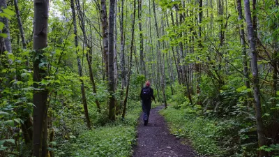
Outdoor destinations, including beaches, parks, natural areas, and trails, have become very popular during the pandemic. For those with cars, getting to these places is usually not too difficult. However, for those without a vehicle, it is challenging to get anywhere outside the urban core of most cities. In this article, Gregory Scruggs writes about how King County (WA) and a number of cities and organizations are working to expand public transit service to parks and trailheads so that more people can access and enjoy the great outdoors. (To better understand how the pandemic has impacted outdoor recreation, read this article and the report it references.)
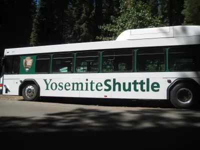
Specifically, the article features King County's Trailhead Direct which is a pilot project co-led by King County Metro and King County Parks. This project seeks to ease vehicle congestion, reduce safety hazards, and expand access to hiking destinations along I-90. For the 2021 season, Trailhead Direct is offering service to Mt Si and Issaquah on weekends and holidays from June 5th, 2021 to September 26th, 2021.
To learn more about this model transit to trails system and other efforts nationwide, please read the source article.
FULL STORY: The Cities Trailblazing Transit Service into the Wilderness

A Shuttle Ride to the Trailhead
A pilot program by King County Metro and the King County Parks Department in the state of Washington found success in 2017, and is spending the beginning of 2018 looking at options to expand.

King County Supportive Housing Program Offers Hope for Unhoused Residents
The county is taking a ‘Housing First’ approach that prioritizes getting people into housing, then offering wraparound supportive services.
Report: One-Fifth of Seattle Households Are Car-Free
According to one local writer, the city’s low rate of car ownership should encourage officials to support public transit and reduce parking minimums.

Maui's Vacation Rental Debate Turns Ugly
Verbal attacks, misinformation campaigns and fistfights plague a high-stakes debate to convert thousands of vacation rentals into long-term housing.

Planetizen Federal Action Tracker
A weekly monitor of how Trump’s orders and actions are impacting planners and planning in America.

Chicago’s Ghost Rails
Just beneath the surface of the modern city lie the remnants of its expansive early 20th-century streetcar system.

Bend, Oregon Zoning Reforms Prioritize Small-Scale Housing
The city altered its zoning code to allow multi-family housing and eliminated parking mandates citywide.

Amtrak Cutting Jobs, Funding to High-Speed Rail
The agency plans to cut 10 percent of its workforce and has confirmed it will not fund new high-speed rail projects.

LA Denies Basic Services to Unhoused Residents
The city has repeatedly failed to respond to requests for trash pickup at encampment sites, and eliminated a program that provided mobile showers and toilets.
Urban Design for Planners 1: Software Tools
This six-course series explores essential urban design concepts using open source software and equips planners with the tools they need to participate fully in the urban design process.
Planning for Universal Design
Learn the tools for implementing Universal Design in planning regulations.
planning NEXT
Appalachian Highlands Housing Partners
Mpact (founded as Rail~Volution)
City of Camden Redevelopment Agency
City of Astoria
City of Portland
City of Laramie