


Using a series of mid-century guidebooks, a new project seeks to uncover historic LGBTQ spaces around the country.
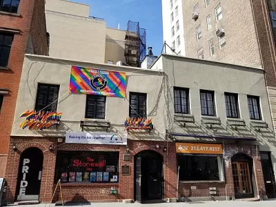
Eric Gonzaba, a historian and professor at California State University, Fullerton (CSUF), has launched a project aimed at "uncovering and preserving hidden histories" in the LGBTQ community as presented in "a series of travel guides published by Bob Damron to map historic queer spaces across the United States," also known as the 'Gay Guides.'
As Marianne Dhenin writes in Next City, the guides were produced by Bob Damron, "a traveling businessman who took note of the gay or at least gay-friendly bars, bathhouses, theaters, bookstores, restaurants, and shops he discovered on his many trips." Now, Mapping the Gay Guides has made the guides into an interactive map loaded with information about important sites and its importance in gay history.
Since its launch in February 2020, Mapping the Gay Guides has dropped hundreds of pins on its interactive map across all 50 states, Washington D.C., Guam, Puerto Rico, and the Virgin Islands (Damron did not distinguish between entries in the U.S. Virgin Islands and the British Virgin Islands, so neither does Mapping the Gay Guides) from the 1965 to 1980 address books. The project received a $350,000 grant from the National Endowment for the Humanities (NEH) in April 2021, which will allow it to spend the next three years digitizing, transcribing, and geolocating data from the 1981 to 2000 guides.
In working on the project, Gonzaba also felt motivated by "a fairly depressing moment in queer communities across the country dealing with the collapse of LGBTQ spaces" as many businesses shuttered, some permanently, during the pandemic. But he cautions that understanding the context of the guides matters: they "were authored by a gay, white man from the relatively progressive city of San Francisco" with his own biases. "Mapping the Gay Guides exemplifies the many colorful possibilities of a digital history project handled with appropriate care. Like other creative digital projects, it can give users a fresh perspective on their cities" and uncover hidden and suppressed histories.
FULL STORY: A New Project Is Bringing the Gay ‘Green Book’ Online


LGBTQ+ Elders Face Compounded Challenges in Accessing Fair and Equitable Housing
Lessons for building affirming, inclusive, and trauma-informed housing developments for older LGBTQ+ adults.

COVID-19, AIDS, and CDC Guidance
Music critic Joel Rozen pens a unique perspective for Slate's "Coronavirus Diaries" on the Provincetown, Massachusetts cluster that prompted the CDC on July 27 to reverse its masking guidance for the fully vaccinated issued a month earlier.

Historic Preservation of LGBTQ Spaces
New research seeks to provide a better understanding of the relationship between historic preservation and neighborhood change in the LGBTQ community.

Planetizen Federal Action Tracker
A weekly monitor of how Trump’s orders and actions are impacting planners and planning in America.

Maui's Vacation Rental Debate Turns Ugly
Verbal attacks, misinformation campaigns and fistfights plague a high-stakes debate to convert thousands of vacation rentals into long-term housing.

San Francisco Suspends Traffic Calming Amidst Record Deaths
Citing “a challenging fiscal landscape,” the city will cease the program on the heels of 42 traffic deaths, including 24 pedestrians.

Amtrak Rolls Out New Orleans to Alabama “Mardi Gras” Train
The new service will operate morning and evening departures between Mobile and New Orleans.

The Subversive Car-Free Guide to Trump's Great American Road Trip
Car-free ways to access Chicagoland’s best tourist attractions.

San Antonio and Austin are Fusing Into one Massive Megaregion
The region spanning the two central Texas cities is growing fast, posing challenges for local infrastructure and water supplies.
Urban Design for Planners 1: Software Tools
This six-course series explores essential urban design concepts using open source software and equips planners with the tools they need to participate fully in the urban design process.
Planning for Universal Design
Learn the tools for implementing Universal Design in planning regulations.
Heyer Gruel & Associates PA
JM Goldson LLC
Custer County Colorado
City of Camden Redevelopment Agency
City of Astoria
Transportation Research & Education Center (TREC) at Portland State University
Jefferson Parish Government
Camden Redevelopment Agency
City of Claremont