


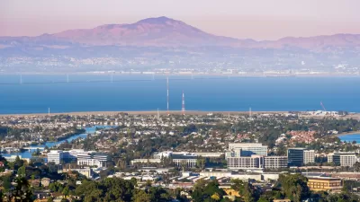
The renaissance predicted for urban areas in the United States started strong during the 2010s but slowed in the years leading up to a potentially generation defining pandemic.

New population estimates from the U.S. Census Bureau "show that the nation’s large cities experienced uneven growth trajectories over the last decade," according to an article by William Frey.
"In the last several years, many cities registered growth slowdowns and declines while the rest of the country rebounded from the Great Recession and the population dispersed toward suburbs and smaller areas," according to Frey's summary of the data. "Some cities grew more rapidly than their surrounding suburbs in the early 2010s, but for many, this is no longer the case."
The analysis breaks down by city size, with population figures for cities with more than 1 million residents (10 cities), cities with populations between 500,000 and 1 million (27 cities), and cities with populations between 250,000 and 500,000 (52 cities). Frey also provides analysis of specific cities within that first, largest group, and explains why growth slowed in the nation's largest cities, shifting to suburban locations, in the second half of the decade.
As for what the future holds, Frey offers this speculation:
There are a lot of unknowns, making this difficult to predict. But it is worth noting that big cities registered their highest growth rates during the down economy and deflated housing market in the wake of the Great Recession. Thus, there is a possibility that young adults—both millennials and Gen Z—may again gravitate to big cities as the pandemic recedes and gives way to a recovering economy.
FULL STORY: American cities saw uneven growth last decade, new census data show


The 15 Fastest-Growing Cities in the US
The U.S. Census Bureau released new 2023 population estimates on May 16 showing a slew of data for cities of all sizes and regions. Do you know the population change last year for the 15 largest cities in your state?
California Continues its Losing Streak
California's population continued to shrink for a third consecutive year according to the U.S. Census Bureau's population estimates for the year ending July 2022, but business columnist Jonathan Lansner saw glimmers of hope in the data.
The Pandemic Population Picture Comes Into Focus
Big U.S. cities lost population as the pandemic loitered into its second year. Suburban cities in Idaho, Arizona, Texas, and Florida grew the fastest during that time.

Planetizen Federal Action Tracker
A weekly monitor of how Trump’s orders and actions are impacting planners and planning in America.

Chicago’s Ghost Rails
Just beneath the surface of the modern city lie the remnants of its expansive early 20th-century streetcar system.

San Antonio and Austin are Fusing Into one Massive Megaregion
The region spanning the two central Texas cities is growing fast, posing challenges for local infrastructure and water supplies.

German Cities Subsidize Taxis for Women Amid Wave of Violence
Free or low-cost taxi rides can help women navigate cities more safely, but critics say the programs don't address the root causes of violence against women.

New Atlanta Law Requires ‘Cool Roofs’
Painting roofs with reflective coatings can significantly reduce indoor temperatures and improve energy efficiency, sometimes at a lower cost than traditional roof treatments.

MTA Poised to Break Ridership, On-Time Service Records
New York City’s transit system saw strong increases in ridership and improvements in service quality in the first half of 2025.
Urban Design for Planners 1: Software Tools
This six-course series explores essential urban design concepts using open source software and equips planners with the tools they need to participate fully in the urban design process.
Planning for Universal Design
Learn the tools for implementing Universal Design in planning regulations.
planning NEXT
Appalachian Highlands Housing Partners
Mpact (founded as Rail~Volution)
City of Camden Redevelopment Agency
City of Astoria
City of Portland
City of Laramie