


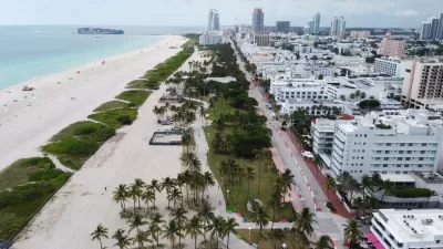
Rising seas are already impacting drinking water supplies in Miami-Dade County.

"It’s a gentle intruder, moving stealthily underground, out of sight but not undetected. Salt water continues to move farther inland in Florida’s Miami-Dade County, albeit at a slower rate," writes Brett Walton.
That conclusion evidenced by data collected by newly released maps from the U.S. Geological Survey.
The encroachment of salt water on underground aquifers is especially troubling because of Miami-Dade County's reliance on underground water. "All of Miami-Dade County’s municipal water, which serves several million residents and visitors, comes from groundwater, primarily from a thin lens of fresh water called the Biscayne Aquifer," according to Walton.
The USGS has mapped the boundary between salt and fresh water at the base of the Biscayne Aquifer. "The leading edge of the saltwater layer in the southeastern part of the county, the area of greatest intrusion, moved inland at a pace of 102 meters per year between 2014 and 2018," according to Walton.
FULL STORY: Tracking the Atlantic Ocean’s Inland Creep in Miami-Dade County


'Climate Gentrification' Is Exacerbating Economic Inequality in Miami
A new study shows that over the last several decades the price of real estate has been heavily influenced by the actual and anticipated effects of climate change.
Low-Income Communities Left Behind in the Sea-Level Rise Discussion
The recent Florid King Tide provided more evidence that some communities in Miami-Dade County have been prioritized bin the ongoing response to sea-level rise.
Miami Loses Population for the First Time Since 1970
Already one of the nation’s hottest real estate markets before the Covid-19 pandemic, the region became unaffordable for many middle-income households in the last few years.

Maui's Vacation Rental Debate Turns Ugly
Verbal attacks, misinformation campaigns and fistfights plague a high-stakes debate to convert thousands of vacation rentals into long-term housing.

Planetizen Federal Action Tracker
A weekly monitor of how Trump’s orders and actions are impacting planners and planning in America.

Chicago’s Ghost Rails
Just beneath the surface of the modern city lie the remnants of its expansive early 20th-century streetcar system.

Bend, Oregon Zoning Reforms Prioritize Small-Scale Housing
The city altered its zoning code to allow multi-family housing and eliminated parking mandates citywide.

Amtrak Cutting Jobs, Funding to High-Speed Rail
The agency plans to cut 10 percent of its workforce and has confirmed it will not fund new high-speed rail projects.

LA Denies Basic Services to Unhoused Residents
The city has repeatedly failed to respond to requests for trash pickup at encampment sites, and eliminated a program that provided mobile showers and toilets.
Urban Design for Planners 1: Software Tools
This six-course series explores essential urban design concepts using open source software and equips planners with the tools they need to participate fully in the urban design process.
Planning for Universal Design
Learn the tools for implementing Universal Design in planning regulations.
planning NEXT
Appalachian Highlands Housing Partners
Mpact (founded as Rail~Volution)
City of Camden Redevelopment Agency
City of Astoria
City of Portland
City of Laramie