


A recently published mapping project is the first step toward California leveraging some of it surplus land for the purposes of developing affordable housing.
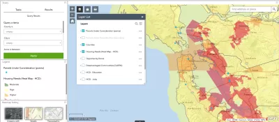
California's Department of General Services (DGS) and Department of Housing and Community Development (HCD) have created a map of surplus state-owned properties with the potential for development as affordable housing development.
The map is the result of an executive order by California Governor Gavin Newsom, issued in January 2019, ordering the creation of the map.
"State properties that were under-utilized or excess to need were identified and then screened to determine which sites would be potentially suitable for affordable housing development," according to a press release announcing the new map.
"The resulting GIS-enabled map is searchable, fully interactive, showing each site identified in the inventory, with a 'heat map' overlay indicating where housing is most needed in the state."
The press release also promises that DGC and HCD will begin in September 2019 to issue requests for proposals for development of some of the sites.


California Governor's Budget Supports Infill Development
Governor Newsom's new budget proposes incentives for developers to build housing in existing urban areas away from fire-prone zones to reduce fire risk and add to the state's insufficient housing stock.

Sports Stadiums as a Battleground for Affordable Housing
Thanks to new enforcement powers, California's Department of Housing and Community Development can now cite cities for failing to meet affordable housing requirements in stadium redevelopment projects.

State Audit Faults California's Affordable Housing Development Processes
The California State Auditor's office is proposing an overhaul of the state's approach to affordable housing development, citing the cost burdens of the housing market as proof of the necessity for change.

Maui's Vacation Rental Debate Turns Ugly
Verbal attacks, misinformation campaigns and fistfights plague a high-stakes debate to convert thousands of vacation rentals into long-term housing.

Planetizen Federal Action Tracker
A weekly monitor of how Trump’s orders and actions are impacting planners and planning in America.

San Francisco Suspends Traffic Calming Amidst Record Deaths
Citing “a challenging fiscal landscape,” the city will cease the program on the heels of 42 traffic deaths, including 24 pedestrians.

Defunct Pittsburgh Power Plant to Become Residential Tower
A decommissioned steam heat plant will be redeveloped into almost 100 affordable housing units.

Trump Prompts Restructuring of Transportation Research Board in “Unprecedented Overreach”
The TRB has eliminated more than half of its committees including those focused on climate, equity, and cities.

Amtrak Rolls Out New Orleans to Alabama “Mardi Gras” Train
The new service will operate morning and evening departures between Mobile and New Orleans.
Urban Design for Planners 1: Software Tools
This six-course series explores essential urban design concepts using open source software and equips planners with the tools they need to participate fully in the urban design process.
Planning for Universal Design
Learn the tools for implementing Universal Design in planning regulations.
Heyer Gruel & Associates PA
JM Goldson LLC
Custer County Colorado
City of Camden Redevelopment Agency
City of Astoria
Transportation Research & Education Center (TREC) at Portland State University
Jefferson Parish Government
Camden Redevelopment Agency
City of Claremont