


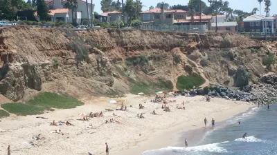
The app, developed by tech mogul Sean Parker (of Napster and Facebook fame), brings technology and environmental regulation together to give people the information they need to get to public beaches.

A new app called YourCoast will help visitors locate and reach public beaches along the California coastline. Beach access has been a contentious issue, with a number of cases of wealthy beachfront property owners intentionally restricting or preventing public access. Sean Parker, who founded Napster and was Facebook’s first president, tangled with the California Coastal Commission in 2013 right before his wedding in Big Sur, in a redwood grove that had been closed off but was designated a public campground.
Parker paid a $2.5 million fine and also agreed to help the agency develop the app, which includes over 1,500 beach access points. "Click on a particular access point and the app shows photos of the path to the beach — which can often be hard to find — and whether there are amenities such as parking, access for disabled visitors (with information on how to procure a beach wheelchair), restrooms or fishing facilities," report Rosanna Xia and Sam Dean.
The app took five years to complete, largely due to technical and staff limitations on the commission’s end. The commission will maintain and update the database information and photos. Parker’s team is helping with the iOS app rollout, and the commission plans to develop an Android version.
FULL STORY: Sean Parker built Napster and helped lead Facebook. Now he’ll guide you to the beach

Coastal City Rejects 'Managed Retreat' Strategy
Del Mar, in Southern California, says it does not want to adopt the approach as part of its sea-level rise adaptation plan.
Court Reinstates Coastal Commission's Decision on San Diego Harbor Island Project
A long-running legal battle over proposed hotel developments in San Diego appears to have come to an end.
California Cracks Down on Beach Blocking Scofflaws
The California Coastal Commission has a powerful new tool to go after homeowners who block access to the state's beaches—the CC can now fine such scofflaws instead of taking them to court.

Planetizen Federal Action Tracker
A weekly monitor of how Trump’s orders and actions are impacting planners and planning in America.

Chicago’s Ghost Rails
Just beneath the surface of the modern city lie the remnants of its expansive early 20th-century streetcar system.

San Antonio and Austin are Fusing Into one Massive Megaregion
The region spanning the two central Texas cities is growing fast, posing challenges for local infrastructure and water supplies.

Since Zion's Shuttles Went Electric “The Smog is Gone”
Visitors to Zion National Park can enjoy the canyon via the nation’s first fully electric park shuttle system.

Trump Distributing DOT Safety Funds at 1/10 Rate of Biden
Funds for Safe Streets and other transportation safety and equity programs are being held up by administrative reviews and conflicts with the Trump administration’s priorities.

German Cities Subsidize Taxis for Women Amid Wave of Violence
Free or low-cost taxi rides can help women navigate cities more safely, but critics say the programs don't address the root causes of violence against women.
Urban Design for Planners 1: Software Tools
This six-course series explores essential urban design concepts using open source software and equips planners with the tools they need to participate fully in the urban design process.
Planning for Universal Design
Learn the tools for implementing Universal Design in planning regulations.
planning NEXT
Appalachian Highlands Housing Partners
Mpact (founded as Rail~Volution)
City of Camden Redevelopment Agency
City of Astoria
City of Portland
City of Laramie