


Storm resilience is a key design element of Hunter’s Point South Park in New York.
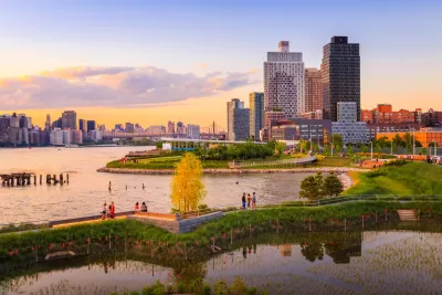
Karim Doumar reports on Hunter’s Point South Park, an 11-acre park that has transformed what was once a waterfront industrial area in Long Island City, Queens. The park includes storm resilient design features, which Doumar says have already proven successful:
As phase one neared completion in 2012, Hurricane Sandy and its 4-foot storm surge inundated the entire thing. And then, calmly and with great precision, the water drained right back out into the river at a pace the sewer system could handle, leaving the park intact. Construction resumed just days later.
The second phase, which opened in June, has also been designed to withstand storm effects. “Instead of concrete walls and buttresses guarding the plot from the river, this park is the river’s friend. Twice a day, as the high tide rolls in, Hunters Point South Park becomes a marsh,” says Doumar. Future plans for the surrounding area include 5,000 units of housing for middle- and low-income residents.
For now, says Doumar, Hunter’s Point South Park is an example of how green infrastructure can be a successful buffer against the forces of nature while also providing recreational space. “Instead of concrete buttresses that once dominated the riverside, Hunters Point South Park’s relationship with the river is dominated by slow, rocky descents into the sea, and a tide that works with the landscape.”
FULL STORY: A Storm-Resilient Park in Queens


Planetizen Federal Action Tracker
A weekly monitor of how Trump’s orders and actions are impacting planners and planning in America.

Maui's Vacation Rental Debate Turns Ugly
Verbal attacks, misinformation campaigns and fistfights plague a high-stakes debate to convert thousands of vacation rentals into long-term housing.

San Francisco Suspends Traffic Calming Amidst Record Deaths
Citing “a challenging fiscal landscape,” the city will cease the program on the heels of 42 traffic deaths, including 24 pedestrians.

Defunct Pittsburgh Power Plant to Become Residential Tower
A decommissioned steam heat plant will be redeveloped into almost 100 affordable housing units.

Trump Prompts Restructuring of Transportation Research Board in “Unprecedented Overreach”
The TRB has eliminated more than half of its committees including those focused on climate, equity, and cities.

Amtrak Rolls Out New Orleans to Alabama “Mardi Gras” Train
The new service will operate morning and evening departures between Mobile and New Orleans.
Urban Design for Planners 1: Software Tools
This six-course series explores essential urban design concepts using open source software and equips planners with the tools they need to participate fully in the urban design process.
Planning for Universal Design
Learn the tools for implementing Universal Design in planning regulations.
Heyer Gruel & Associates PA
JM Goldson LLC
Custer County Colorado
City of Camden Redevelopment Agency
City of Astoria
Transportation Research & Education Center (TREC) at Portland State University
Jefferson Parish Government
Camden Redevelopment Agency
City of Claremont