


The High Line in New York City has inspired ambitious projects all over the country. A pedestrian bridge proposed to connect the Arlington neighborhood of Crystal City to the Reagan National Airport provides the latest example.
If all goes according to plan, travelers and residents might be able to use a pedestrian connection between Ronald Reagan Washington National Airport and the Crystal City neighborhood in Arlington, Virginia.
The Crystal City Business Improvement District (BID) "is unveiling a proposal for a connection between the city and the airport that would make that walk a lot easier and more pleasant," reports Nena Perry-Brown.
"While details on the exact construction of either a bridge or tunnel have yet to be determined, the BID seems particularly taken with the idea of building a bridge akin to the High Line in New York City, a style and aesthetic that seems to have become the go-to model for jurisdictions looking to build walkable bridges," according to Perry-Brown.
The proposed bridge project will require coordination between the BID, the Virginia Railway Express, and the county of Arlington. The pedestrian bridge is designed to take advantage of a $1 billion capital improvements project underway at the airport under the guidance of the Metropolitan Washington Airports Authority.
FULL STORY: Crystal City Wants a High Line Bridge Connection to National Airport

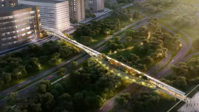
Details Emerging About the Big Pedestrian Bridge Proposed for Arlington County, Virginia
A proposal first revealed in November 2017 has already undergone a substantial amount of planning.
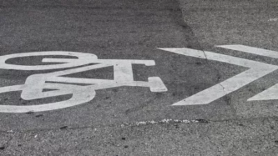
The New New Protected Bike Lane
Protected bike lanes, a relatively new addition to streets in the United States, are already evolving.
5 D.C.-Area Infrastructure Projects Jumpstarted by Amazon
Amazon's decision to locate half of its HQ2 location in Northern Virginia kicks the state into gear on transportation projects. More funding could potentially be on the way.

Maui's Vacation Rental Debate Turns Ugly
Verbal attacks, misinformation campaigns and fistfights plague a high-stakes debate to convert thousands of vacation rentals into long-term housing.

Planetizen Federal Action Tracker
A weekly monitor of how Trump’s orders and actions are impacting planners and planning in America.

Chicago’s Ghost Rails
Just beneath the surface of the modern city lie the remnants of its expansive early 20th-century streetcar system.

Bend, Oregon Zoning Reforms Prioritize Small-Scale Housing
The city altered its zoning code to allow multi-family housing and eliminated parking mandates citywide.

Amtrak Cutting Jobs, Funding to High-Speed Rail
The agency plans to cut 10 percent of its workforce and has confirmed it will not fund new high-speed rail projects.

LA Denies Basic Services to Unhoused Residents
The city has repeatedly failed to respond to requests for trash pickup at encampment sites, and eliminated a program that provided mobile showers and toilets.
Urban Design for Planners 1: Software Tools
This six-course series explores essential urban design concepts using open source software and equips planners with the tools they need to participate fully in the urban design process.
Planning for Universal Design
Learn the tools for implementing Universal Design in planning regulations.
planning NEXT
Appalachian Highlands Housing Partners
Mpact (founded as Rail~Volution)
City of Camden Redevelopment Agency
City of Astoria
City of Portland
City of Laramie