


City Profiles
Explore cities through an urban planning lens.
San Antonio: An Urban Planner's Guide to the City
Anchored by its picturesque river, San Antonio is a diverse city experiencing rapid growth in the shadow of its larger Texas neighbors.
Basics
- State: Texas
- Founded: 1718
- Incorporation date: 1837
- Area: 504.64 square miles
- Statehood: 1845
- Population: 1,513,974 (2024 Estimate)
- Type of government: Council-Manager
- Planning department website: COSA Planning Department
- Comprehensive plan: SA Tomorrow
Indigenous history and the impact of colonization
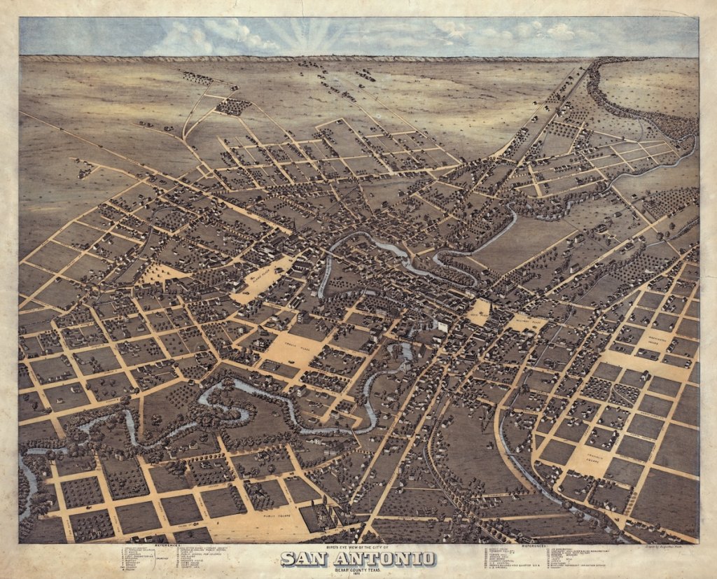
The Payaya indigenous peoples (a sect of Coahuiltecans) inhabited the San Antonio River Valley for thousands of years. Their existence revolved around the San Pedro Springs, which they called Yanaguana (“refreshing waters”). While colonialism erased much of their history and culture, Spanish records note that they were hunter-gatherer tribes who subsisted heavily on local nuts (particularly, pecans), which necessitated a traveling lifestyle. Early European explorers described them as peaceful and accommodating to foreigners, though they were formidable fighters in battle.
Álvar Núñez Cabeza de Vaca, a shipwrecked Spaniard who was briefly enslaved by natives, encountered the San Antonio River during his explorations into Central Texas in the mid-1500’s. After his departure to Mexico, few European explorers ventured that far inland until the next century. In 1691, Spanish missionaries encountered the indigenous peoples around present-day La Villita on June 13 – the feast of Saint Anthony of Padua. As such, they named the river and surrounding area San Antonio.
At the turn of the century, explorers in the region began lobbying the Spanish Crown for resources to establish Catholic missions in the area. In 1716, the Viceroyalty of New Spain granted permission for these endeavors, which fell under the governor of Coahuila y Tejas. Fray Antonio de Olivares led the construction of the first Spanish buildings at the site, which include the Mision San Antonio de Valero (The Alamo) and the Presidio San Antonio de Bexar with the assistance of the Payaya people.
As the Spanish expanded their settlement to include other nearby missions, there arose a need to irrigate land and provide access to water using the San Antonio River and the nearby San Pedro Creek. As such, the Spanish took on the task of creating miles of acequias and aqueducts to transport water throughout the area. Remnants of these engineering feats are still present in the city today, and the iconography of the acequia has become part of the identity of Downtown San Antonio.
In 1719, the Spanish Crown began transporting families from the Canary Islands to populate the area. The legacy of the early Canary Islanders is ingrained in the identity of the city, and San Antonio is now a sister city of Las Palmas. In the next hundred years, the population of European and mestizo inhabitants grew exponentially, and San Antonio became the capital of the Mexican state of Tejas.
This period is still very visible in Downtown San Antonio, as small Spanish streets with narrow sidewalks characterize the area in and around La Villita. Architecturally, the city has tried to preserve the original colonial aesthetics that make it unique. The City of San Antonio logo currently sits in a neat quatrefoil, itself harkening back to the curved Moorish arches of those early Spanish missions.
Revolutionary legacy
As Anglo settlers from the United States made their way into Texas, cultural shifts began taking place. Disagreements over how to handle the issue of slavery led many Anglo-Texans to call for secession from Mexico, which had recently abolished the act. In 1836, Mexican President Antonio Lopez de Santa Ana marched his troops to San Antonio for the famous Battle of the Alamo. Eventually, his army overwhelmed the Texian forces, and the Alamo fell on March 16.
Just one month later, Santa Ana’s troops fell to General Sam Houston at the Battle of San Jacinto in just 18 minutes. Shortly thereafter, the Republic of Texas was erected as Santa Ana signed the Treaties of Velasco under duress. This independence was short-lived, as Texas petitioned the United States government to admit it into the Union in 1845.
Following this annexation, tensions with Mexico rose and the Mexican-American War tore through Texas. San Antonio was decimated during this period, and the population fell to a fraction of its former size. Following the United States’ victory, the population quickly rebounded, and some estimate that 15,000 inhabitants lived in San Antonio by 1860 as the Civil War broke out.
Immigration and diversity
In 1859, the famed architect Frederick Law Olmsted visited San Antonio and documented his trip in A Journey Through Texas (1859). At this point, the presence of German immigrants was ubiquitous. Olmsted briefly describes this in a chapter titled “Approach to the Germans,” where he notes an interest in a local newspaper called the San Antonio Zeitung. Arriving into the city from New Braunfels, he describes the stark transition from German limestone houses to humble Mexican cottages that surround The Alamo. For a moment, he stops on a bridge and peers over the San Antonio River: “We irresistibly stop to examine it, we are so struck with its beauty. It is of a rich blue and pure as crystal, flowing rapidly but noiselessly over pebbles and between reedy banks. One could lean for hours over the bridge-rail.”
Continuing on his exploration of the city, Olmsted observes: “We have no city, except, perhaps, New Orleans, that can vie, in point of the picturesque interest that attaches to odd and antiquated foreignness, with San Antonio. Its jumble of races, costumes, languages and buildings; its religious ruins, holding to an antiquity, for us, indistinct enough to breed an unaccustomed solemnity; its remote, isolated, outposted situation, and the vague conviction that it is the first of a new class of conquered cities into whose decaying streets our rattling life is to be infused, combine with the heroic touches in its history to enliven and satisfy your traveler's curiosity.”
Indeed, the remarkable and unique diversity of San Antonio continues to characterize it today. During the 19th Century, German immigrants erected beautiful Victorian and Italianate mansions south of the Alamo in the King William neighborhood (named for King Wilhelm I of Prussia). To the west of the Alamo, Italian immigrants made their home around the present-day Piazza Italia Park (though the neighborhood was mostly razed in the mid-1900’s to construct Highway 35). Poles, Czechs, and eventually Irish families were welcomed to San Antonio during this period, and their prominent families’ names still mark some of the most noteworthy corridors of the city.
20th-century growth
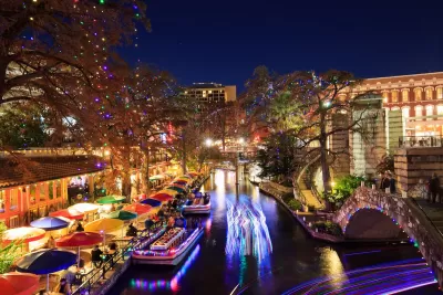
The beauty of the San Antonio River that Olmsted stopped to admire almost two centuries ago was untamable, and rampant flooding routinely devastated locals around it. Following a particularly destructive flood in 1921, local leaders began conceptualizing ways to tame the river through dams and bypass channels. However, as conservationists protested these efforts, local architect Robert Hugman worked with city officials to create a bond project that would fund the original 2.5-mile stretch of the Riverwalk. Hugman’s designs for the area eventually came to life with assistance from the Works Progress Administration. The Riverwalk has been expanded over time to incorporate the Museum Reach and the Mission Reach, but the original Downtown portion remains an iconic part of San Antonio’s identity and one of the most-visited tourist destinations in Texas.
Yet as the city and federal government invested in San Antonio, not everyone felt the impact of these advancements. Just as it did across much of the country, redlining cemented segregation in San Antonio for generations to come. As European Americans settled on the Northside, Mexican-Americans made the Westside their home and the Eastside became the black neighborhood that it still is today. Through segregation ordinances and special covenants in deeds that prohibited Mexican-Americans and blacks from living in the white suburbs (Alamo Heights, Olmos Park, Mahncke Park, etc.), local officials effectively halted the ability for homeowners in the Eastside and Westside to generate equity in their homes and create generational wealth. The history of redlining in San Antonio is well-documented, and its effects are still very clearly visible today.
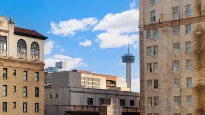
Though it is now a prominent fixture in San Antonio’s skyline, the Tower of the Americas came at the cost of many local families who called that area home. As Hemisfair was developed in preparation for the 1968 World’s Fair, the shotgun houses that lined the area north of the present-day Lavaca District were seized using eminent domain to make way for attractions that catered to a population that was not them. This trend continued as the Federal Highway Act of 1956 provided millions of dollars in funding for interstate highways. I-10, I-35, I-37, and US-281 came at the cost of hundreds (if not thousands) of homes that were cleared in the name of progress. Today, the city is atoning for these errors, as the concrete barriers of massive highways have contributed to segregation in the city and continue to ensure that the Westside, Eastside, and Southside are cut off from Downtown.
A new growth spurt
Following a period of relative stagnation and slow growth, San Antonio gained global recognition for its cultural assets, as the original Spanish colonial missions became a collective UNESCO World Heritage Site in 2015. Shortly thereafter, San Antonio became recognized as a UNESCO City of Gastronomy, joining Tucson as the only other city with this designation in the country. Furthermore, San Antonio has successfully leveraged its Sister City relationships to expand its brand into Europe, Africa, Asia, and Latin America.
Today, San Antonio is one of the fastest-growing cities in the country, and it is on pace to become the sixth largest city in the United States. San Antonio has also been able to leverage its Military City, USA branding to stimulate economic development that is partially centered around the major military installation, Joint-Base San Antonio (JBSA). This has contributed greatly to innovation in the bioscience, defense tech, and aerospace industries, which help drive the local economy.
But with growth comes the challenge of managing it responsibly. During the mayoral administration of Julian Castro (later, Secretary of Housing and Urban Development under President Obama), San Antonio launched the SA2020 initiative, which was aimed at improving the quality of life and economic stability for locals by 2020. Under the leadership of Mayor Ron Nirenberg, the city has begun implementing the SA Tomorrow Comprehensive Plan to ensure growth is managed in a way that accounts for sustainability, resiliency, equity, and economic prosperity. This effort, along with the SA Tomorrow Sustainability Plan and the SA Tomorrow Multimodal Transportation Plan, is set to ensure that these goals are implemented in the next couple of decades.
Planning milestones
- 1718: The first Spanish colonial mission in the area is established as Mision San Antonio de Valero (The Alamo).
- 1731: La Villa de San Fernando (later, the City of San Antonio) elects its first alcalde (mayor), Juan Leal Goraz.
- 1837: Following the victory of the Texian army’s fight for independence from Mexico, San Antonio is incorporated as a city within the Republic of Texas.
- 1845: Texas is admitted into the Union as the 28th state.
- 1921: A flood decimates Downtown San Antonio and leads local officials to work towards a means of controlling water levels and revitalizing the area.
- 1937: Following years of lobbying for support from the state and federal government, the Texas Legislature creates the San Antonio River Authority (SARA) to oversee the management of the San Antonio River.
- 1939: The Riverwalk project breaks ground with backing from the Works Progress Administration.
- 1941: The original stretch of the Riverwalk is completed, along with the Arneson River Theater and La Villita.
- 1964: Interests in the Riverwalk evolve from flood mitigation to economic development, and local voters approve a $500,000 bond to finance the Paseo del Rio improvements (a plan to incorporate more retail and hospitality into the area).
- 1968: San Antonio hosts the World’s Fair and completes construction of Hemisfair and the Tower of the Americas.
- 1997: San Antonio adopts its first comprehensive planning document, the Master Plan Policies.
- 2014: San Antonio embarks on creating a new comprehensive plan, titled the SA Tomorrow Comprehensive Plan, along with a Multimodal Transportation Plan and a Sustainability Plan.
- 2021: San Antonio City Council adopts the Strategic Housing Implementation Plan (SHIP), to guide housing incentives and investments from 2022: 2031.
- 2023: San Antonio City Council adopts the Economic Development Strategic Framework to outline small business support strategies, placemaking investments, and targeted industry incentive mechanisms.
- 2024: San Antonio begins the process of creating a Transit-Oriented Policy Framework to guide land use and development around the city’s first rapid-transit corridor.
This city profile was authored by Matthew Reyes.


San Antonio and Austin are Fusing Into one Massive Megaregion
The region spanning the two central Texas cities is growing fast, posing challenges for local infrastructure and water supplies.
San Antonio Remains Affordable as City Grows
The city’s active efforts to keep housing costs down through housing reforms and coordinated efforts among city agencies and developers have kept it one of the most affordable in the nation despite its rapid population growth.

New Intercity Bus Service Will Connect Texas Cities
A San Antonio-based charter bus company will begin offering daily trips to Dallas-Fort Worth and San Antonio later this year.
Urban Design for Planners 1: Software Tools
This six-course series explores essential urban design concepts using open source software and equips planners with the tools they need to participate fully in the urban design process.
Planning for Universal Design
Learn the tools for implementing Universal Design in planning regulations.
planning NEXT
Appalachian Highlands Housing Partners

Mpact (founded as Rail~Volution)
City of Camden Redevelopment Agency
City of Astoria
City of Portland
City of Laramie