


The Boston Planning & Development Agency released a powerful new map of the entire city—complete with layers like shadows, flood plains, and zoning districts—to the public.
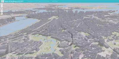
Tim Logan reports on a new digital 3D map produced by the Boston Planning & Development Agency (BDPA) that models the entire city.
The map is "the latest step in the BPDA’s push to be more transparent, and to spark conversations about planning for the city’s future," according to Logan. Previously, BDPA housed a wooden scale model on the ninth floor of City Hall. The new digital map is public, and the hope is that it will inspire the public to engage with the city's development in new ways.
The map maps 129,000 buildings from East Boston to Mottapan, explains Logan. "The map is pannable and scannable, and detailed enough to capture backyard sheds, rooftop furniture, and lots of trees. And it comes with tools that allow anyone to layer on zoning maps, schools, MBTA stops, and even flood-prone areas."
FULL STORY: You can see your home from here. A new 3D map covers the entire city


Boston to Launch New Downtown Plan
The Boston Planning & Development Agency will hire consultants to craft a vision for its rapidly changing downtown.

Boston Gets a New Planning Department
After 67 years since its formation, the Boston Planning and Development Agency is no more.

Boston to Begin Zoning Code Update, Mayor Announces
It’s been nearly 60 years, but the city of Boston is finally ready to do a comprehensive rewrite of its zoning code.

Maui's Vacation Rental Debate Turns Ugly
Verbal attacks, misinformation campaigns and fistfights plague a high-stakes debate to convert thousands of vacation rentals into long-term housing.

Planetizen Federal Action Tracker
A weekly monitor of how Trump’s orders and actions are impacting planners and planning in America.

In Urban Planning, AI Prompting Could be the New Design Thinking
Creativity has long been key to great urban design. What if we see AI as our new creative partner?

King County Supportive Housing Program Offers Hope for Unhoused Residents
The county is taking a ‘Housing First’ approach that prioritizes getting people into housing, then offering wraparound supportive services.

Researchers Use AI to Get Clearer Picture of US Housing
Analysts are using artificial intelligence to supercharge their research by allowing them to comb through data faster. Though these AI tools can be error prone, they save time and housing researchers are optimistic about the future.

Making Shared Micromobility More Inclusive
Cities and shared mobility system operators can do more to include people with disabilities in planning and operations, per a new report.
Urban Design for Planners 1: Software Tools
This six-course series explores essential urban design concepts using open source software and equips planners with the tools they need to participate fully in the urban design process.
Planning for Universal Design
Learn the tools for implementing Universal Design in planning regulations.
planning NEXT
Appalachian Highlands Housing Partners
Mpact (founded as Rail~Volution)
City of Camden Redevelopment Agency
City of Astoria
City of Portland
City of Laramie