


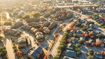
A Harvard study suggests that since 2000, the number of Americans living in racially integrated neighborhoods has risen. But this may be a temporary effect of gentrification, and integration remains an exception to the rule.

Reporting on their research brief for the Harvard Joint Center for Housing Studies, study authors Shannon Rieger and Jonathan Spader discuss a rise in integrated neighborhoods since the year 2000.
The study looks at two measures of neighborhood integration: 1) tracts "where no racial or ethnic group accounts for 50 percent or more of the population," and 2) tracts where "any community of color makes up at least 20 percent of the tract population AND if the tract is at least 20 percent white." Both measures suggest increased integration from 2000 through the time period of the 2011-2015 American Community Survey.
Ongoing gentrification may be behind this in some places, rather than long-term integration. Spader and Rieger write, "While some of these neighborhoods may become stably integrated areas, it is not yet clear how many of the newly integrated neighborhoods will become stably integrated and how many will eventually become non-integrated areas." In addition, the majority of Americans still live in neighborhoods that fulfill neither definition of integration.
FULL STORY: Are Integrated Neighborhoods Becoming More Common in the United States?

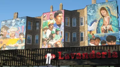
Can Gentrification Integrate Neighborhoods?
Hector Tobar argues that despite the well-documented ills of gentrification, under the right circumstances it can eat into long decades of racial segregation. Eastern Los Angeles may be a prime test case.
Is Exclusionary Zoning a Good Thing?
Some commentators defend exclusionary suburban zoning on the ground that it makes affluent suburbanites more willing to pay for public services. But does exclusion create losers?
In Defense of Asian American Neighborhoods
How do you address a history of anti-Asian housing discrimination? Not by destroying Asian American communities.

Maui's Vacation Rental Debate Turns Ugly
Verbal attacks, misinformation campaigns and fistfights plague a high-stakes debate to convert thousands of vacation rentals into long-term housing.

Planetizen Federal Action Tracker
A weekly monitor of how Trump’s orders and actions are impacting planners and planning in America.

Chicago’s Ghost Rails
Just beneath the surface of the modern city lie the remnants of its expansive early 20th-century streetcar system.

Bend, Oregon Zoning Reforms Prioritize Small-Scale Housing
The city altered its zoning code to allow multi-family housing and eliminated parking mandates citywide.

Amtrak Cutting Jobs, Funding to High-Speed Rail
The agency plans to cut 10 percent of its workforce and has confirmed it will not fund new high-speed rail projects.

LA Denies Basic Services to Unhoused Residents
The city has repeatedly failed to respond to requests for trash pickup at encampment sites, and eliminated a program that provided mobile showers and toilets.
Urban Design for Planners 1: Software Tools
This six-course series explores essential urban design concepts using open source software and equips planners with the tools they need to participate fully in the urban design process.
Planning for Universal Design
Learn the tools for implementing Universal Design in planning regulations.
planning NEXT
Appalachian Highlands Housing Partners
Mpact (founded as Rail~Volution)
City of Camden Redevelopment Agency
City of Astoria
City of Portland
City of Laramie