


The city hopes to accelerate development and mitigate flood risk along the industrial Fort Point Channel with a string of new parks.
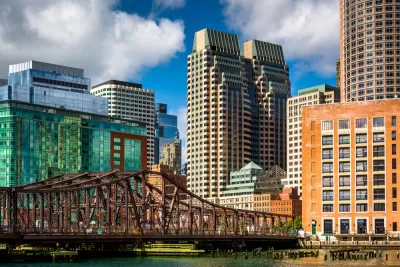
Mayor Martin Walsh and the Trustees of Reservations have released plans for a network of parks along the Fort Point Channel, which they hope will both attract investment to the industrial corridor and mitigate the impacts of sea-level rise on its low-lying neighborhoods.
The channel runs from Boston Harbor to the railyard between South Boston and the South End, and is "one of the hottest pockets in Boston's real estate market," according to the Boston Globe. Conceptual designs call for connecting the parks through pedestrian bridges and artificial islands, bringing a string of green space to an area that is anticipating both major new development—from Amazon and GE—and increasing flood risk.
A recently issued report, “Climate Ready Boston,” identified Fort Point Channel as a throughway that could allow water to inundate low-lying areas of the South End and Roxbury. Shoring it up — by changing the topography, installing water-absorbing marshlands, and giving water someplace to flow safely — could have great benefits.
Those benefits would extend from Fort Point to the downtown area, Chinatown, and South Boston, according to the mayor.
FULL STORY: Park plan envisions fun — and flood control — along Fort Point


Cities Turn to Highway Cap Parks for Economic Development
Some worry that, of the many reasons cities pursue cap parks, creating quality green space is low on the list.

Study: How Urban Parks Can Support Biodiversity
Conservation and recreation can go hand in hand in urban green spaces designed to serve both humans and local wildlife.

Updating LA’s Tree Rules Could Bring More Shade to Underserved Neighborhoods
A new USC study finds that relaxing Los Angeles’ outdated tree planting guidelines could significantly expand urban tree canopy and reduce shade disparities in lower-income neighborhoods, though infrastructure investments are also needed.

Maui's Vacation Rental Debate Turns Ugly
Verbal attacks, misinformation campaigns and fistfights plague a high-stakes debate to convert thousands of vacation rentals into long-term housing.

Planetizen Federal Action Tracker
A weekly monitor of how Trump’s orders and actions are impacting planners and planning in America.

In Urban Planning, AI Prompting Could be the New Design Thinking
Creativity has long been key to great urban design. What if we see AI as our new creative partner?

King County Supportive Housing Program Offers Hope for Unhoused Residents
The county is taking a ‘Housing First’ approach that prioritizes getting people into housing, then offering wraparound supportive services.

Researchers Use AI to Get Clearer Picture of US Housing
Analysts are using artificial intelligence to supercharge their research by allowing them to comb through data faster. Though these AI tools can be error prone, they save time and housing researchers are optimistic about the future.

Making Shared Micromobility More Inclusive
Cities and shared mobility system operators can do more to include people with disabilities in planning and operations, per a new report.
Urban Design for Planners 1: Software Tools
This six-course series explores essential urban design concepts using open source software and equips planners with the tools they need to participate fully in the urban design process.
Planning for Universal Design
Learn the tools for implementing Universal Design in planning regulations.
planning NEXT
Appalachian Highlands Housing Partners
Gallatin County Department of Planning & Community Development
Mpact (founded as Rail~Volution)
City of Camden Redevelopment Agency
City of Astoria
City of Portland
City of Laramie