


Building on the edge of natural areas comes with risks, including wildfires and landslides. Colorado Springs will try to discover the extent of the risk from the latter at the western edge of the city.
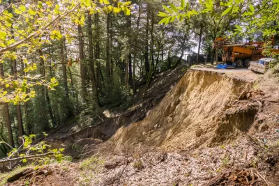
The city of Colorado Springs has procrastinated long enough it seems, and will finally take on an expensive study of the Cheyenne Mountain landslide complex, which is two miles long and impacting housing developments and a golf course.
"Colorado Springs is undertaking a $500,000 study of the enormous Cheyenne Mountain landslide complex, nearly 1½ years after being urged to do so quickly by the Colorado Geological Study," reports Billie Stanton Anleu.
In April 2016, State Geologist Karen Berry was quoted warning the city that "[l]ittle is known about the depth of the landslide, its rate of movement, the aerial extent of movement, or the toe of past and current slope movement," but the landslide could be "extensive."
A 500-year storm exacerbated the landslide in May 2015.
FULL STORY: Colorado Springs commissions study of massive landslide complex


Southern California City Offers Buyout to Homeowners Facing Erosion Threat
Power and gas were shut off to dozens of homes in Rancho Palos Verdes as landslides threatened homes and infrastructure. Now, the city is offering to buy the homes to help residents relocate.

Colorado Springs Motel Converted to Supportive Housing
A vacant motel now offers 12 supportive housing units for formerly homeless women.

Southern California Utilities Cut Power, Gas to Hundreds of Households on Shifting Coastal Land
Slow but significant land movement is damaging infrastructure, prompting power shutoffs and calls for evacuation in Rancho Palos Verdes.

Maui's Vacation Rental Debate Turns Ugly
Verbal attacks, misinformation campaigns and fistfights plague a high-stakes debate to convert thousands of vacation rentals into long-term housing.

Planetizen Federal Action Tracker
A weekly monitor of how Trump’s orders and actions are impacting planners and planning in America.

In Urban Planning, AI Prompting Could be the New Design Thinking
Creativity has long been key to great urban design. What if we see AI as our new creative partner?

King County Supportive Housing Program Offers Hope for Unhoused Residents
The county is taking a ‘Housing First’ approach that prioritizes getting people into housing, then offering wraparound supportive services.

Researchers Use AI to Get Clearer Picture of US Housing
Analysts are using artificial intelligence to supercharge their research by allowing them to comb through data faster. Though these AI tools can be error prone, they save time and housing researchers are optimistic about the future.

Making Shared Micromobility More Inclusive
Cities and shared mobility system operators can do more to include people with disabilities in planning and operations, per a new report.
Urban Design for Planners 1: Software Tools
This six-course series explores essential urban design concepts using open source software and equips planners with the tools they need to participate fully in the urban design process.
Planning for Universal Design
Learn the tools for implementing Universal Design in planning regulations.
planning NEXT
Appalachian Highlands Housing Partners
Mpact (founded as Rail~Volution)
City of Camden Redevelopment Agency
City of Astoria
City of Portland
City of Laramie