


"Smell-mapping" is gaining attention from urban planners, data scientists, and nature conservationists alike.
Next week, artist Kate McLean will lead "smellwalks" through London, inviting participants to guess at mysterious scents and sniff strangers (with their consent.)
McLean is an artist, but her work is part of a data science project that could have implications for real estate and virtual reality tech. At GoodCityLife.org, researchers track keywords on social media to create digital "smellscapes"—color-coded maps marked red for emissions, green for nature, and so on.
Citymetric explores the possible applications of this work—like enhancing tours of national parks, or improving virtual reality technology by introducing "a full sphere of perceptions of a space."
And, if home values reflect "the positivity of the environment," smell-mapping could even affect real estate. One researcher hopes to work with cities on "interventions" in places with low-scoring smells, especially if those odors correspond to potential health risks. In part for that reason, the project measures a place's smell against people's perceptions of it, ranking places' "Likeability". For instance:
The Bayshore Freeway in San Francisco, for example, predominantly smells of emissions, according to the data … The emotion most commonly affiliated with the freeway is "sadness."
FULL STORY: How city "smell-mappers" can help virtual reality, real estate and how we understand the past

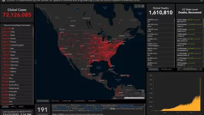
How Mapping Tools Played a Role in Understanding COVID-19
A new episode of the Geospatial Revolution Project assesses how scientists used digital mapping tools to think about the pandemic.
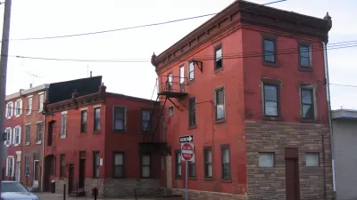
Real-Estate Site Locates Redevelopment Potential Across Philadelphia
A new map-based web tool created by a former city employee calculates the redevelopment potential of every parcel in Philadelphia.
Virtual Reality a Game Changer for Real Estate
The New York Times details how virtual reality is expected to change the game of real estate. The possibilities for planners and architects are endless as well.

Maui's Vacation Rental Debate Turns Ugly
Verbal attacks, misinformation campaigns and fistfights plague a high-stakes debate to convert thousands of vacation rentals into long-term housing.

Planetizen Federal Action Tracker
A weekly monitor of how Trump’s orders and actions are impacting planners and planning in America.

In Urban Planning, AI Prompting Could be the New Design Thinking
Creativity has long been key to great urban design. What if we see AI as our new creative partner?

California Creates Housing-Focused Agency
Previously, the state’s housing and homelessness programs fell under a grabbag department that also regulates the alcohol industry, car mechanics, and horse racing.

Chicago’s Ghost Rails
Just beneath the surface of the modern city lie the remnants of its expansive early 20th-century streetcar system.

Baker Creek Pavilion: Blending Nature and Architecture in Knoxville
Knoxville’s urban wilderness planning initiative unveils the "Baker Creek Pavilion" to increase the city's access to green spaces.
Urban Design for Planners 1: Software Tools
This six-course series explores essential urban design concepts using open source software and equips planners with the tools they need to participate fully in the urban design process.
Planning for Universal Design
Learn the tools for implementing Universal Design in planning regulations.
planning NEXT
Appalachian Highlands Housing Partners
Mpact (founded as Rail~Volution)
City of Camden Redevelopment Agency
City of Astoria
City of Portland
City of Laramie