


Love 'em or hate 'em, drones are coming. But is the issue of aesthetics getting enough treatment in the drone wars?

The idea of drones zipping overhead is both fascinating and alarming. I bet people had similar thoughts when automobiles were first invented—back in the days when urban streets were mostly occupied by pedestrians, horses, and carts. When autos became more common and street usage eventually tipped toward cars, did people think, "Public life will never feel the same again?" Should we return to these thoughts in light of drones? While drones and cars might not be equivalent comparisons, they are similar in that they represent new occupation of public space.
Whether the proliferation of small unmanned aircraft systems (the federal parlance, of our times) is good or bad is a worthwhile policy debate. In the mean time we can be thankful for the FAA's recent adoption of rules to ensure their safe operation.
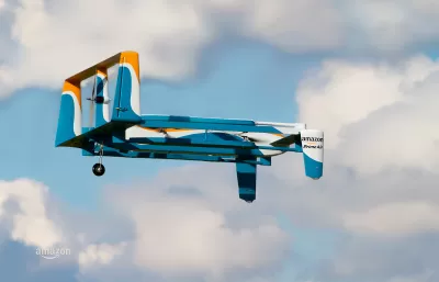
There are compelling reasons to use drones, for example law enforcement, emergency response, and military operations; data collection in remote or dangerous areas; and agriculture management. On the other hand people also have legitimate concerns about the use of drones, as noted in this CBS News article. Most of the reasons cited in the article relate to safety and privacy. But should we also be talking about aesthetics? In the article, Reason #6: Crowded Skies, hints at this, with the discussion of Amazon Prime Air.
If drones go mainstream and Amazon.com's vision for Prime Air (and similar commercial enterprises) becomes as common as the everyday delivery truck, the way we experience outdoor life will feel different. Consider this argument: The skies are like wilderness. While there are countless airplanes overhead at any given time, they operate at such a high altitude we barely notice them. Aside from takeoff and landing, commercial airplanes are silent little specks dotting an otherwise pristine sky.
Closer toward earth, the only human-powered moving objects are the occasional news or police helicopter. Otherwise, the flying objects in our everyday airspace are predominantly operated by mother nature: birds, insects, falling leaves, rain. Will it feel strange to suddenly see commercial delivery drones occupying this natural space? Will it be distracting or annoying? If we are out for a walk in our neighborhood and see an Amazon drone buzz by and land in a back yard down the street, will we just shrug our shoulders, and think, "The Andersons must be out of toothpaste," and continue on as if the event was no more significant than a passing car? If we are headed toward a future that looks like Coruscant from Star Wars, then the aesthetics issue is small by comparison, but the Galactic Republic probably held more than one Senate hearing on where residents can park their flying vehicles.
Drones as a policy debate will be more complete if it includes the issue of aesthetics.
Generations ago, we accepted that airplanes would enter our lives. But a plane at 30,000 feet does not feel intrusive while standing on the ground (it also doesn't have a camera attached to it). True, the take-off and landing of aircraft does have a very significant aesthetic impact. In response to this, communities around the country have adopted airport-related zoning and land use regulations to address this issue in a manner that balances quality of life and safe airport/aircraft operations.
But the underlying premise of airport-related zoning regulations is that airplanes land at a predictable location: the airport. This is not the same for Amazon Prime Air and similar services. Commercial aerial package delivery (translated into land use speak) would mean that instead of one or two landing sites for aircraft in a community, there are, well, as many potential sites as there are customers. To address this as a land use matter, local land use regulation will need to take a different approach than traditional airport zoning, and I doubt that one massive Drone Overlay District blanketing an entire city will be popular in city council hearings.
To regulate drones at the local level, planners will need to think creatively about the issues they are trying to address, and especially whether commercial aerial package delivery fits within conventional residential zoning districts. Is allowed as a by-right use? If so, how is the use defined, and what special standards should be attached to the use to ensure safe operations, compatibility with adjacent land uses, and preservation of community character? Would Amazon need a local business license in every jurisdiction it serves? Alternatively, if the service is treated as a special use or conditional use, then how would the proposed operation be evaluated given that the land use impacts are so dispersed? It’s like trying to regulate Uber as a land use.
Integrating aesthetics into the conversation about drones will help in the eventual crafting of local zoning and land use regulations that are sensible, comprehensive, and effectively administered. For regulatory ideas, the Humanitarian Space blog published an article titled, "Zoning and Urban Land Use Planning for Drones," which includes a checklist of questions related to drone technology and site planning that can help policy-makers think through the implications of drone regulations.
Are drones and commercial aerial package delivery the inevitable future? Amazon clearly wants us to think so, and perhaps they are right. The service would be convenient, and could even reduce traffic and lower fossil fuel usage by taking delivery vehicles off the roads. But, the ultimate argument in favor of drones might just be that they are really cool. So, planners may want to start thinking about the future of zoning maps, and making our traditional 2D zoning maps cooler too….like a 3D zoning model showing where our toothpaste will land.

To Build More Housing, Cities Must Be Smarter in How They Use Land
How strategic land use policy decisions can alleviate the housing crisis and limit unsustainable sprawl.

Land Use Reform Picks Up Momentum in Connecticut Again
Multiple statewide land use reform proposals are up for debate in the Nutmeg State. Which, if any, will become law?

The Local Causes of Inflation
Although it is widely seen as a national issue, decisions made at the local level often have a stronger impact on inflation than federal policies.

Planetizen Federal Action Tracker
A weekly monitor of how Trump’s orders and actions are impacting planners and planning in America.

Vehicle-related Deaths Drop 29% in Richmond, VA
The seventh year of the city's Vision Zero strategy also cut the number of people killed in alcohol-related crashes by half.

Map: Where Senate Republicans Want to Sell Your Public Lands
For public land advocates, the Senate Republicans’ proposal to sell millions of acres of public land in the West is “the biggest fight of their careers.”

Berlin to Consider Car-Free Zone Larger Than Manhattan
The area bound by the 22-mile Ringbahn would still allow 12 uses of a private automobile per year per person, and several other exemptions.

The Ratio of Older People to Children Grew in Every State
Older adults outnumber youth in 11 U.S. states.

LA Transit Ridership Plummets Amidst ICE Raids
LA Metro’s bus and rail lines are seeing up to 15 percent lower ridership in the wake of violent immigration arrests.
Urban Design for Planners 1: Software Tools
This six-course series explores essential urban design concepts using open source software and equips planners with the tools they need to participate fully in the urban design process.
Planning for Universal Design
Learn the tools for implementing Universal Design in planning regulations.
Heyer Gruel & Associates PA
JM Goldson LLC
Custer County Colorado
City of Camden Redevelopment Agency
City of Astoria
Transportation Research & Education Center (TREC) at Portland State University
Camden Redevelopment Agency
City of Claremont
Municipality of Princeton (NJ)