


A new visualization from the Smithsonian's National Museum of Natural History shows how the earth "breathes"—in the form of volcanic eruptions, earthquakes, and emissions.

"Pretend that you're an alien in a spacecraft above Earth. You are looking down and watching the pulse of planet Earth. The breath, the respiration," says Elizabeth Cottrell, as quoted in an article by Sarah Kaplan.
Cottrell is a research geologist who directs the Global Volcanism Program at the National Museum of Natural History. She's describing the action of a new visualization of the planet's eruptions, earthquakes, and gas emissions. As she rotates the globe with a click of her mouse, blue dots signifying tremors and red triangles for volcanoes flare up and fade away, carving the planet's surface in predictable patterns. The animation emits a 'ping"'with each earthshaking event," writes Kaplan to explain the visualization.
The article provides additional discussion of why the visualization could be considered "cool" or "fascinating" rather than terrifying (especially for those of us living in California).
FULL STORY: Watch Earth pulse with earthquakes and eruptions in this stunning visualization

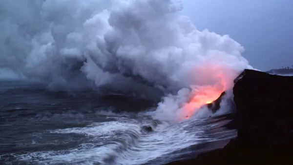
Friday Eye Candy: Mount Kilauea’s Volcanic Activity, Past and Present
Newly released images from NASA's terra satellite chronicles the history of lava on Hawaii's Big Island.

New California Law Regulates Warehouse Pollution
A new law tightens building and emissions regulations for large distribution warehouses to mitigate air pollution and traffic in surrounding communities.
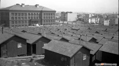
The 120 Year Old Tiny Home Villages That Sheltered San Francisco’s Earthquake Refugees
More than a century ago, San Francisco mobilized to house thousands of residents displaced by the 1906 earthquake. Could their strategy offer a model for the present?

Planetizen Federal Action Tracker
A weekly monitor of how Trump’s orders and actions are impacting planners and planning in America.

Maui's Vacation Rental Debate Turns Ugly
Verbal attacks, misinformation campaigns and fistfights plague a high-stakes debate to convert thousands of vacation rentals into long-term housing.

San Francisco Suspends Traffic Calming Amidst Record Deaths
Citing “a challenging fiscal landscape,” the city will cease the program on the heels of 42 traffic deaths, including 24 pedestrians.

Defunct Pittsburgh Power Plant to Become Residential Tower
A decommissioned steam heat plant will be redeveloped into almost 100 affordable housing units.

Trump Prompts Restructuring of Transportation Research Board in “Unprecedented Overreach”
The TRB has eliminated more than half of its committees including those focused on climate, equity, and cities.

Amtrak Rolls Out New Orleans to Alabama “Mardi Gras” Train
The new service will operate morning and evening departures between Mobile and New Orleans.
Urban Design for Planners 1: Software Tools
This six-course series explores essential urban design concepts using open source software and equips planners with the tools they need to participate fully in the urban design process.
Planning for Universal Design
Learn the tools for implementing Universal Design in planning regulations.
Heyer Gruel & Associates PA
JM Goldson LLC
Custer County Colorado
City of Camden Redevelopment Agency
City of Astoria
Transportation Research & Education Center (TREC) at Portland State University
Jefferson Parish Government
Camden Redevelopment Agency
City of Claremont