


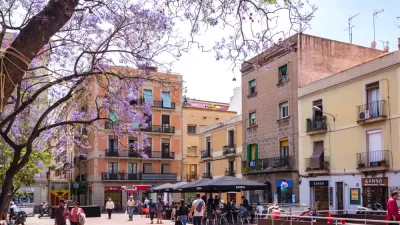
Barcelona wants to be the world’s best city for people. To reclaim the public space and community living that residents lost to cars over the last century, the city is transforming mobility and access to public space by introducing the superblock.
When Catalan urban planner Ildefons Cerdà i Sunyer, back in the 1850s, designed the Eixample, the expansion of Barcelona outside the old city walls, he envisioned a city based on community living, where people could interact on wide streets, with a wealth of public and private gardens, and where transportation of people and goods wouldn’t dominate public space.
What Cerdà could not foresee in his plan, approved by the city on 1859, was the arrival of the automobile and the resulting transformation of mobility that took place in the middle of the 20th century.
The Barcelona government, however, has a new plan, which aims to reclaim most of the streets for the community, without reducing traffic flow. The plan is modeled on the original idea of the Eixample, and expands the area into “Super Illes”, the Catalan term for Superblocks.
FULL STORY: Superblocks, Barcelona Answer to Car-Centric City

Could Los Angeles Emulate Barcelona’s ‘Superblocks’?
A proposal in the city council could bring the ‘superblock’ model to Los Angeles, opening up neighborhood streets to more biking, walking, and public amenities.

Barcelona's Long-Term, Pedestrian-First Plan Continues with the 'Barcelona Superblock'
Mayor Ada Colau announced the next step in Barcelona's plan to convert the city center into a "new city for the present and the future."

What Would Cities Look Like if They Were Designed by Women?
Cities are built by men, and so too often urban design does not reflect the needs, perspectives, and realities of women.

Maui's Vacation Rental Debate Turns Ugly
Verbal attacks, misinformation campaigns and fistfights plague a high-stakes debate to convert thousands of vacation rentals into long-term housing.

Planetizen Federal Action Tracker
A weekly monitor of how Trump’s orders and actions are impacting planners and planning in America.

In Urban Planning, AI Prompting Could be the New Design Thinking
Creativity has long been key to great urban design. What if we see AI as our new creative partner?

King County Supportive Housing Program Offers Hope for Unhoused Residents
The county is taking a ‘Housing First’ approach that prioritizes getting people into housing, then offering wraparound supportive services.

Researchers Use AI to Get Clearer Picture of US Housing
Analysts are using artificial intelligence to supercharge their research by allowing them to comb through data faster. Though these AI tools can be error prone, they save time and housing researchers are optimistic about the future.

Making Shared Micromobility More Inclusive
Cities and shared mobility system operators can do more to include people with disabilities in planning and operations, per a new report.
Urban Design for Planners 1: Software Tools
This six-course series explores essential urban design concepts using open source software and equips planners with the tools they need to participate fully in the urban design process.
Planning for Universal Design
Learn the tools for implementing Universal Design in planning regulations.
planning NEXT
Appalachian Highlands Housing Partners
Mpact (founded as Rail~Volution)
City of Camden Redevelopment Agency
City of Astoria
City of Portland
City of Laramie