


More than any other place, wildlife have impact on human health, quality of life and aesthetics in urban areas. Thinking about city planning at the terrestrial wildlife scale could support mutual objectives of city planning.
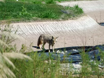
In my city, a coyote is killed by a motorist every four days; for deer, that ratio slims to more than one per day. As Professor Richard Forman writes of the phenomenon, streets are the primary animal sink in cities; the input of animals is greater than the output. That is, more animals begin crossing the road than complete the crossing. In fact, thousands of animals every year in any given metropolis don’t make the crossing.
Many techniques have been employed to decrease road kills: roadside reflectors, mirrors, repellents, bait, various fencing types, one-way gates (to escape from fenced roadsides), lighting, wildlife crossing signs, and animated warning signs for motorists. The laundry list is long, and success is marginal. As Forman continues, these techniques generally show modest or no success.
Marching from automobile-dependency is not novel to planning a better city. But instead of the usual anthropocentric view of improving the scale of cities for the pedestrian—walkability, in a word—we can look to wildlife as a frame of reference for better city planning (for humans and wildlife). In this view, the thousands of pavement pelts is an indicator of not only dead animals but a city not responsive to pedestrians.
Back to Forman: Wildlife science has increasingly focused on urban environments realizing that the most pressing wildlife conservation challenges are urban in nature. Sprawl from urban areas into natural areas and wildlife habitat remains a primary threat to native species and biodiversity.
Thus a sprawling city is not just a human issue. Much as paving greater distances between our day-to-day needs erodes the human-scale city, so too does the city challenge urban wildlife.
Returning to Forman: Urban development removes and fragments habitats, thereby threatening long-term conservation of wildlife species less able to persist in smaller, more isolated habitat patches.
If we swap Forman’s use "habitat" for "community," we shine a headlight on the human/wildlife nexus; the automobile infrastructure fragmented community stresses and isolates us.
As a human(e) city needs a safe and comfortable pedestrian environment—a city landscape that de-prioritizes the motorist—wildlife too benefits. When crossing a road becomes a necessity, we seek crosswalks, pedestrian bridges, or we can jaywalk the milder street. For terrestrial wildlife, they can cross a land-surface-level bridge over a sunken road, or an overpass above the land-surface road. An iconic example of the latter is the successful wildlife overpasses in Banff National Park. Anecdotally, in cities coyotes have been observed using pedestrian bridges.
Forman again: the proximity of humans and wildlife in urban areas leads to more human-wildlife interactions than in any other setting; therefore, more than any other place, wildlife have more impact on human health, quality of life, education and aesthetics in urban areas.
I’d add that, more than any other place, humans have more impact on wildlife health and quality of life. The goal of building a city for humans—for walking, for community, for social justice—mirrors the outcomes of a wildlife city. Perhaps we ought to expand our typical research focus and look to wildlife for a good city form.
Connect with Steven on Twitter @stevenpsnell or Facebook stevenpsnell. Download his novel, Clear Running Water, at Makin Books.


Maui's Vacation Rental Debate Turns Ugly
Verbal attacks, misinformation campaigns and fistfights plague a high-stakes debate to convert thousands of vacation rentals into long-term housing.

Planetizen Federal Action Tracker
A weekly monitor of how Trump’s orders and actions are impacting planners and planning in America.

San Francisco Suspends Traffic Calming Amidst Record Deaths
Citing “a challenging fiscal landscape,” the city will cease the program on the heels of 42 traffic deaths, including 24 pedestrians.

Detroit Says Problems With Property Tax Assessments are Fixed. Advocates Disagree.
With higher-valued properties under assessed and lower-valued properties over assessed, advocates say there's still a problem with Detroit's property tax system.

Defunct Pittsburgh Power Plant to Become Residential Tower
A decommissioned steam heat plant will be redeveloped into almost 100 affordable housing units.

Trump Prompts Restructuring of Transportation Research Board in “Unprecedented Overreach”
The TRB has eliminated more than half of its committees including those focused on climate, equity, and cities.
Urban Design for Planners 1: Software Tools
This six-course series explores essential urban design concepts using open source software and equips planners with the tools they need to participate fully in the urban design process.
Planning for Universal Design
Learn the tools for implementing Universal Design in planning regulations.
Heyer Gruel & Associates PA
JM Goldson LLC
Custer County Colorado
City of Camden Redevelopment Agency
City of Astoria
Transportation Research & Education Center (TREC) at Portland State University
Jefferson Parish Government
Camden Redevelopment Agency
City of Claremont