


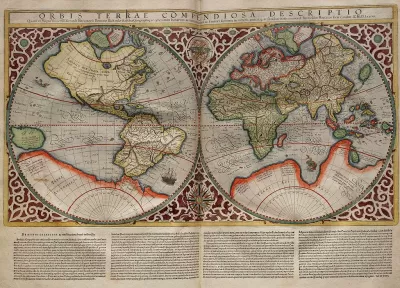
Typical world maps badly misrepresent the size of countries; a new web app shows their true scale.
The True Size Of is an interactive app that seeks to improve our skewed sense of global geography by correcting the world map.
The web app allows users to drag a country to another part of the map. The country's size and shape will change until it compares accurately to its new location.
For a little background on why "the world's most ubiquitous map" is so distorted, Liz Stinson at Wired explains:
The Mercator projection is an inherently flawed design. It exaggerates the size of countries closest to the poles while depicting size most faithfully at the equator. Though it was once a handy navigational tool for sailors, the map has instilled in the rest of us a gross misunderstanding of geography and relative country size.
FULL STORY: Fascinating App Shows You How Misleading Maps Can Be

Mapped: Every Building in the United States
Using data from Microsoft, the New York Times has published an online map showing the placement of every building in the country, in a simple black and white format.

The Importance of Geographic Literacy
Maps are still an important tool in teaching kids to be global citizens.
Putting Alternative Fuel Stations on the Map
Yesterday, the U.S. Department of Energy released an interactive map displaying thousands of alternative fuel stations around the nation.

Maui's Vacation Rental Debate Turns Ugly
Verbal attacks, misinformation campaigns and fistfights plague a high-stakes debate to convert thousands of vacation rentals into long-term housing.

Planetizen Federal Action Tracker
A weekly monitor of how Trump’s orders and actions are impacting planners and planning in America.

In Urban Planning, AI Prompting Could be the New Design Thinking
Creativity has long been key to great urban design. What if we see AI as our new creative partner?

King County Supportive Housing Program Offers Hope for Unhoused Residents
The county is taking a ‘Housing First’ approach that prioritizes getting people into housing, then offering wraparound supportive services.

Researchers Use AI to Get Clearer Picture of US Housing
Analysts are using artificial intelligence to supercharge their research by allowing them to comb through data faster. Though these AI tools can be error prone, they save time and housing researchers are optimistic about the future.

Making Shared Micromobility More Inclusive
Cities and shared mobility system operators can do more to include people with disabilities in planning and operations, per a new report.
Urban Design for Planners 1: Software Tools
This six-course series explores essential urban design concepts using open source software and equips planners with the tools they need to participate fully in the urban design process.
Planning for Universal Design
Learn the tools for implementing Universal Design in planning regulations.
planning NEXT
Appalachian Highlands Housing Partners
Mpact (founded as Rail~Volution)
City of Camden Redevelopment Agency
City of Astoria
City of Portland
City of Laramie