The Urban Accessibility Explorer is an easy-to-use mapping system that measures the number of activities that can be reached by residents of specified neighborhoods within a given amount of travel time, by a particular mode and time of day.



(Updated 04/16/2015) The Metropolitan Chicago Accessibility Explorer is an easy-to-use mapping system that measures the number of activities, including various types of jobs, schools, parks, stores and libraries, that can be reached by residents of specified neighborhoods within a given amount of travel time, by a particular mode and time of day in the Chicago Metropolitan area. The results are displayed on maps that can be adjusted by scale and area. The Accessibility Explorer was developed by the Urban Transportation Center, which is a unit of the College of Urban Planning and Public Affairs at the University of Illinois at Chicago help policy makers, planners, and the general public easily evaluate how transportation system and land use change could alter accessibility.
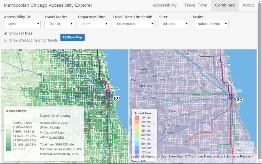
This is an example of a new class of accessibility-based mapping tools, which also includes WalkScore and TransitScore, and the Access To Jobs Mapping System developed by the Regional Planning Association in the New York City region.
These tools help apply accessibility-based planning, which recognizes that the ultimate goal of most transport activity is access to goods and services, and that many factors can affect accessibility including the convenience, speed, and affordability of travel by various modes, transport network connectivity, land use density, and mix, and mobility substitutes such as telecommunications and delivery services.
(The post was updated to give proper credit to the developers of the app.)
Read the full story: Metropolitan Chicago Accessibility Explorer


Transportation for Everyone
An efficient and fair transportation system must serve diverse users. The "Transportation for Everyone" rating system evaluates transport system diversity and, therefore, its ability to serve all community members.
Accessibility-Based Planning
Should society encourage parents to drive children to school rather than walk or bicycle? Should our transportation policies favor driving over walking, cycling, ridesharing, public transit and telecommuting? Probably not. There is no logical reason to favor automobile travel over other forms of accessibility, and there are lots of good reasons to favor efficient modes, so for example, schools spend at least as much to accommodate a walking or cycling trip as an automobile trip, and transportation agencies and employers spend at least as much to improve ridesharing and public transit commuting as automobile commuting.

HUD sets new time limit on Fair Housing accessibility complaints
Previously, complaints could be filed as long as the violation remained.

Planetizen Federal Action Tracker
A weekly monitor of how Trump’s orders and actions are impacting planners and planning in America.

Amtrak, CN end decades-long dispute with eight-year agreement
The new operating agreement establishes an updated framework for the companies to work together, including processes to resolve disputes.

Judges permit Denver to divert 77,000 acre feet from the Colorado River for reservoir expansion
Overuse and climate change have caused the Colorado River’s water levels to plummet.

Alabama scores up to $2.5 billion federal loan for largest infrastructure project in state’s history
The Mobile River Bridge and Bayway Project aims to ease congestion at Alabama’s worst bottleneck.

Trump is considering data centers on 6 states' public land — some state officials say they had no idea
If the administration approves the proposed projects, data center and data center-related developments will cover 17,600 acres of public land.

Despite court ruling, Trump is keeping nearly all wind projects in the US on hold
At least 110 wind energy projects have not heard from the government since a federal judge ruled that the Trump administration's freeze on wind turbine clearances was likely illegal.

FREE Course: Walkable City 1: Why Walkability?
After describing his path towards focusing on walkability as the essence of good planning, Jeff Speck marches through his five principal reasons for making more walkable places.
Reinventing Malls: Planning Alchemy—Turning Gray Fields Into Gold
The course focuses on the opportunities and imperatives that shape reinvention of mall sites.

KFH Group Inc.
Greater Baltimore Committee
Eagle County Government
The Architects Foundation
University of Cincinnati Online
The Pocatello Development Authority
The Urban Renewal Agency of the City of Pocatello