


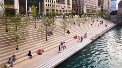
A newly opened section of the Chicago Riverwalk lets the public get up close and personal with the Chicago River. And there's more to come.
John Greenfield reports on the latest of a spree of public space projects in Chicago, a new two-block stretch of the Chicago Riverwalk, between State and Clark, which opened last weekend. According to Greenfield, "[t]he riverwalk extension is slated to reach Lake Street and Wacker Driver next year, creating a car-free pedestrian and bike route all the way to Lake Michigan."
Greenfield's post introduces the new features of the park as well as details about funding (a $100 million federal Transportation Infrastructure Finance Innovation Act loan) and concessions (which will help pay back the loan over 35 years). Greenfield also details the design themes of the Riverwalk and a boots-on-the-ground review of the newest section.
FULL STORY: Eyes on the Street: Checking Out the New Chicago Riverwalk Sections

Celebrating Chicago's Must-See Public Realm (Part 1)
Chicago has recently opened some of the most exciting urban landscapes we have seen in a while. And, as with New York and other cities, landscape architects are leading the charge.
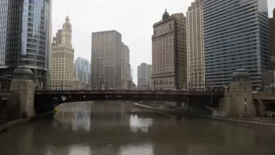
Flooding Provides a Scare for Chicago's Two New Public Spaces
The damage could have been a lot worse, but surely flooding that temporarily closed down the Chicago Riverwalk and The 606 elevated bikeway will require additional evaluation by project planners and engineers.
Chicago Sources River Ideas from Citizens
The Metropolitan Planning Council of Chicago wants to get in on the recent upswing in crowdsourced planning solutions. They are looking to the public for input on the Chicago river system's future.

Maui's Vacation Rental Debate Turns Ugly
Verbal attacks, misinformation campaigns and fistfights plague a high-stakes debate to convert thousands of vacation rentals into long-term housing.

Planetizen Federal Action Tracker
A weekly monitor of how Trump’s orders and actions are impacting planners and planning in America.

Chicago’s Ghost Rails
Just beneath the surface of the modern city lie the remnants of its expansive early 20th-century streetcar system.

Bend, Oregon Zoning Reforms Prioritize Small-Scale Housing
The city altered its zoning code to allow multi-family housing and eliminated parking mandates citywide.

Amtrak Cutting Jobs, Funding to High-Speed Rail
The agency plans to cut 10 percent of its workforce and has confirmed it will not fund new high-speed rail projects.

LA Denies Basic Services to Unhoused Residents
The city has repeatedly failed to respond to requests for trash pickup at encampment sites, and eliminated a program that provided mobile showers and toilets.
Urban Design for Planners 1: Software Tools
This six-course series explores essential urban design concepts using open source software and equips planners with the tools they need to participate fully in the urban design process.
Planning for Universal Design
Learn the tools for implementing Universal Design in planning regulations.
planning NEXT
Appalachian Highlands Housing Partners
Mpact (founded as Rail~Volution)
City of Camden Redevelopment Agency
City of Astoria
City of Portland
City of Laramie