


With support from local governments and bureaucrats, a proposal to transform the existing "M-Path" rail line into a ten-mile linear park is gaining traction in Miami. Next up: an economic impact study.
"GreenLink, a plan to create a 10-mile linear park along the southern Metrorail route, is gaining attention and support and moving ahead with the help of the University of Miami," reports John Charles Robbins.
The University of Miami will complete an economic impact study for the project of the renovation of the M-Path, but according to Robbins, the project has garnered a lot of institutional support at this point in the process. "The proposed renovation of the M-Path for bicycles and pedestrians along US 1, GreenLink is being promoted by various county agencies, including the Miami-Dade County parks and transit departments. The idea to use the underutilized land came from Friends of the GreenLink founder Meg Daly." Also, "Several municipalities have endorsed the proposal including the City of Miami, the City of Coral Gables, the City of South Miami and the Village of Pinecrest."
Robbins also covered the plans to turn the land under the rail line into a park back in June.
FULL STORY: 10-mile linear park gets new look

Revealed: James Corner Field Operations Designs of the 'Underline' in Miami
After transforming opinions about public space with the High Line in New York, James Corner Field Operations will shift focus below the tracks—the Underline park under the MetroRail line in Miami.

Miami Study to Connect Bikers and Pedestrians to Transit
The Transportation Planning Organization will budget a study on how best to connect trails to transit hubs.
Transit Debate Coming to a Head Soon in Miami-Dade
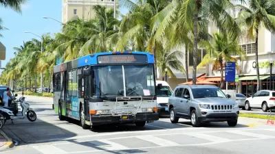
A new network of buses, designed with the bus priority features, has been proposed in Miami. The catch: it would come at the expense of a promised rail extension program.

Maui's Vacation Rental Debate Turns Ugly
Verbal attacks, misinformation campaigns and fistfights plague a high-stakes debate to convert thousands of vacation rentals into long-term housing.

Planetizen Federal Action Tracker
A weekly monitor of how Trump’s orders and actions are impacting planners and planning in America.

Chicago’s Ghost Rails
Just beneath the surface of the modern city lie the remnants of its expansive early 20th-century streetcar system.

Bend, Oregon Zoning Reforms Prioritize Small-Scale Housing
The city altered its zoning code to allow multi-family housing and eliminated parking mandates citywide.

Amtrak Cutting Jobs, Funding to High-Speed Rail
The agency plans to cut 10 percent of its workforce and has confirmed it will not fund new high-speed rail projects.

LA Denies Basic Services to Unhoused Residents
The city has repeatedly failed to respond to requests for trash pickup at encampment sites, and eliminated a program that provided mobile showers and toilets.
Urban Design for Planners 1: Software Tools
This six-course series explores essential urban design concepts using open source software and equips planners with the tools they need to participate fully in the urban design process.
Planning for Universal Design
Learn the tools for implementing Universal Design in planning regulations.
planning NEXT
Appalachian Highlands Housing Partners
Mpact (founded as Rail~Volution)
City of Camden Redevelopment Agency
City of Astoria
City of Portland
City of Laramie