


San Francisco has managed to operate and integrate historic rail transit into its overall public transit system. Clement Lau explains how the City does it.
Lovers of vintage rail travel can get their fill in San Francisco.
Los Angeles County planner Clement Lau recently took a trip to the Bay Area city and shares what he learned about how streetcars and cable cars operate as part of a overall modern transit system.
The F Market and Wharves line uses exclusively historic equipment from both the city’s retired fleet and from municipalities around the world, Lau writes. The San Francisco Municipal Railway (Muni) operates the line, supported by a nonprofit organization called the Market Street Railway that raises funds and helps restore vintage streetcars.
“While historic, the F Market & Wharves line is an integral part of Muni’s intermodal urban transportation network, operating at frequent intervals for 20 hours a day, seven days a week. It carries local commuters and tourists alike, connecting residential, business and leisure oriented areas of the city.”
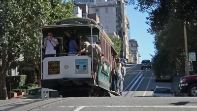
San Francisco’s cable car system, invented in 1873, is iconic and also run by Muni. Once a popular mode of transportation replicated in cities around the world, only three of the 23 lines San Francisco established still operate, according to Lau.
“The vast majority of the 7 million annual passengers on the cable cars are tourists, rather than locals. This reflects the fact that the cable cars are among the most significant tourist attractions in San Francisco. . .”
Visit Urbdezine to read more.
FULL STORY: Vintage Public Transit: San Francisco’s Streetcars and Cable Cars

New Streetcar Line Set to Open August 1 in City by the Bay
As Joe Fitzgerald Rodriguez of the San Francisco Examiner explains, the 'E' Line has only been over three decades in the making. Credit goes greatly to former mayor, now U.S. Senator Diane Feinstein, and the tireless work of committed advocates.
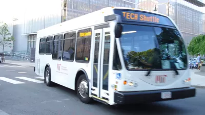
Tech Shuttles: The Bay Area's Seventh Largest Transportation Provider
A new survey has found that every day more than 800 tech buses are traveling on the region's roadways, carrying around 34,000 passengers daily
Thanks to SF's Cable Cars, Bell Tolls for City's Public Transit
They're a global icon of the City by the Bay and one of San Francisco's premier tourist attractions. Operating at a loss, the city's cable cars are also draining resources from more essential forms of public transit, writes Joe Eskenazi.

Maui's Vacation Rental Debate Turns Ugly
Verbal attacks, misinformation campaigns and fistfights plague a high-stakes debate to convert thousands of vacation rentals into long-term housing.

Planetizen Federal Action Tracker
A weekly monitor of how Trump’s orders and actions are impacting planners and planning in America.

In Urban Planning, AI Prompting Could be the New Design Thinking
Creativity has long been key to great urban design. What if we see AI as our new creative partner?

King County Supportive Housing Program Offers Hope for Unhoused Residents
The county is taking a ‘Housing First’ approach that prioritizes getting people into housing, then offering wraparound supportive services.

Researchers Use AI to Get Clearer Picture of US Housing
Analysts are using artificial intelligence to supercharge their research by allowing them to comb through data faster. Though these AI tools can be error prone, they save time and housing researchers are optimistic about the future.

Making Shared Micromobility More Inclusive
Cities and shared mobility system operators can do more to include people with disabilities in planning and operations, per a new report.
Urban Design for Planners 1: Software Tools
This six-course series explores essential urban design concepts using open source software and equips planners with the tools they need to participate fully in the urban design process.
Planning for Universal Design
Learn the tools for implementing Universal Design in planning regulations.
planning NEXT
Appalachian Highlands Housing Partners
Mpact (founded as Rail~Volution)
City of Camden Redevelopment Agency
City of Astoria
City of Portland
City of Laramie