Architecture critic John King tagged along with the Congress for New Urbanism. The latter was recently in San Francisco to examine the benefits of freeway removal. The city's prime case study: Octavia Boulevard.

John King examines "when a double-deck roadway is erased from the map," along with the Congress for New Urbanism, which recently brought a group of visitors in from the "eastern half of the United States" to examine the Octavia Boulevard case study, which replaced a portion of the Central Freeway.
"Octavia Boulevard opened in 2005, nearly 16 years after the Loma Prieta earthquake damaged pillars supporting the elevated concrete roadway erected in 1959. The ramps extending across Hayes Street to Gough and Franklin streets, which never reopened, were dismantled in 1992. But the connection that crossed Market Street to Oak and Fell streets remained in place until 2003, with four elections along the way to decide whether it should stay or go."
"Now the freeway touches down at Market Street before shifting to a boulevard with two lanes of traffic on either side of a median filled by thick poplars. On either side, there's an additional lane for local traffic, set apart from the central lanes by elms and shrubs to buffer the adjacent blocks from the commuter slog."
FULL STORY: Road to rebirth? S.F.'s post-freeway Octavia may be a model

Planetizen Federal Action Tracker
A weekly monitor of how Trump’s orders and actions are impacting planners and planning in America.

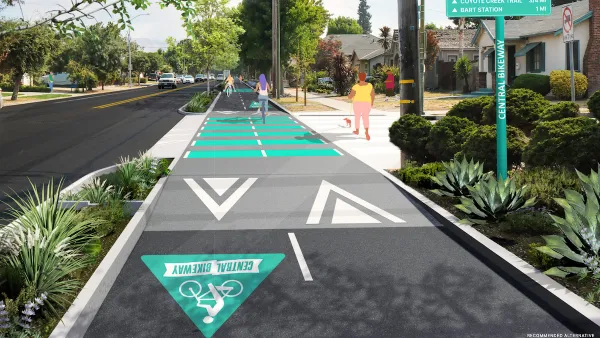
Silicon Valley ‘Bike Superhighway’ Awarded $14M State Grant
A Caltrans grant brings the 10-mile Central Bikeway project connecting Santa Clara and East San Jose closer to fruition.

Amtrak Cutting Jobs, Funding to High-Speed Rail
The agency plans to cut 10 percent of its workforce and has confirmed it will not fund new high-speed rail projects.

Report: One-Fifth of Houston Homes in Flood Areas
The 2025 State of Housing in Harris County and Houston report highlights the health risks posed by inadequate housing.

Chicago Eliminates Parking Minimums Near Transit
Changes to a city ordinance make it easier to build ‘by-right’ car-free developments near train stations and pave the way for more affordable housing.

One Year in, Indy BRT Line is the City’s Most Popular Bus Route
The Purple Line serves over 100,000 riders per month.
Urban Design for Planners 1: Software Tools
This six-course series explores essential urban design concepts using open source software and equips planners with the tools they need to participate fully in the urban design process.
Planning for Universal Design
Learn the tools for implementing Universal Design in planning regulations.
Caltrans
City of Fort Worth
New Jersey Institute of Technology
Mpact (founded as Rail~Volution)
City of Camden Redevelopment Agency
City of Portland
City of Laramie


