


Move over Panama Canal, there’s another waterway that connects one side of the continent to the other. These waters part ways in Wyoming.
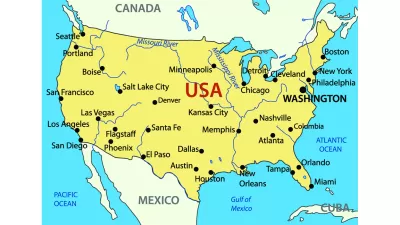
Jesus Diaz shares knowledge of the geographic point of interest known as “Parting of the Waters,” found in the Teton Wilderness Area of the Bridger-Teton National Forest in Wyoming. There, a mountain stream called North Two Ocean Creek meets the Continental Divide and splits into two streams headed opposite directions. One of the streams becomes Atlantic Creek, flowing 3,488 miles east and then south and joining the Yellowstone, Missouri and Mississippi rivers—finally culminating in the Gulf of Mexico. The other stream becomes Pacific Creek, flowing 1,353 miles west and joining the Snake and Columbia rivers—eventually spilling into the Pacific Ocean.
The MyWyoming tourism site has more on the experience of standing one foot in the Pacific and one foot in the Atlantic.
In case you're curious for more waterway-related nomenclature, the streams flowing away from each other are called distributaries—Parting of the Waters just happens to occur at the Continental Divide. For another famous example, reference the Casiquiare River in South America, which flows away from the Orinoco River toward the Rio Negro, a tributary of the Amazon.
And Wyoming includes another place where distributaries split to eventually find very different bodies of water, according to the MyWyoming tourism site: “[at] Three Waters Mountain, near Union Pass, water wends its way to three different major bodies of water, the Gulf of California (the drop travels 1,300 miles), the Pacific (a 1,400-mile trip), and the Gulf of Mexico (3,000-miles distant).”
FULL STORY: This creek divides the US connecting the Atlantic and Pacific oceans

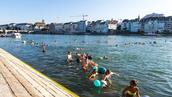
Is Your City Swimmable?
An interview with organizers of the inaugural Swimmable Cities Summit, which took place this June 22-24 in Rotterdam, NL.
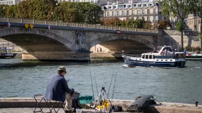
River Seine ‘Teeming’ With Life
Decades of restoration efforts are yielding positive results as dozens of species of fish return to the once-polluted waterway.
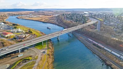
Snohomish River Gains Legal Rights
A new law in one Washington town enshrines the river’s legal right to “exist, regenerate, and flourish.”

Maui's Vacation Rental Debate Turns Ugly
Verbal attacks, misinformation campaigns and fistfights plague a high-stakes debate to convert thousands of vacation rentals into long-term housing.

Planetizen Federal Action Tracker
A weekly monitor of how Trump’s orders and actions are impacting planners and planning in America.

San Francisco Suspends Traffic Calming Amidst Record Deaths
Citing “a challenging fiscal landscape,” the city will cease the program on the heels of 42 traffic deaths, including 24 pedestrians.

Defunct Pittsburgh Power Plant to Become Residential Tower
A decommissioned steam heat plant will be redeveloped into almost 100 affordable housing units.

Trump Prompts Restructuring of Transportation Research Board in “Unprecedented Overreach”
The TRB has eliminated more than half of its committees including those focused on climate, equity, and cities.

Amtrak Rolls Out New Orleans to Alabama “Mardi Gras” Train
The new service will operate morning and evening departures between Mobile and New Orleans.
Urban Design for Planners 1: Software Tools
This six-course series explores essential urban design concepts using open source software and equips planners with the tools they need to participate fully in the urban design process.
Planning for Universal Design
Learn the tools for implementing Universal Design in planning regulations.
Heyer Gruel & Associates PA
JM Goldson LLC
Custer County Colorado
City of Camden Redevelopment Agency
City of Astoria
Transportation Research & Education Center (TREC) at Portland State University
Jefferson Parish Government
Camden Redevelopment Agency
City of Claremont