


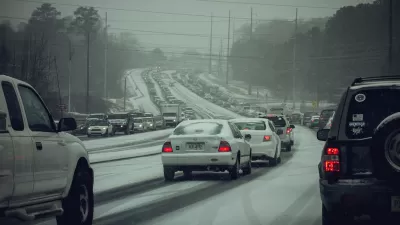
Last week, many Atlantans were stuck in traffic overnight because of fewer than three inches of snow. What went wrong?

Two weeks ago, 2.6 inches of snow shut down metropolitan Atlanta. Because businesses and schools did not close until midday, most of the region's drivers entered its highways at the same time, causing lots of traffic to clog snowy roads. As those roads iced up, drivers were stranded on highways all night, while children were stranded at school or even on school buses. What went wrong?
One oft-discussed factor was the Atlanta region's failure to build more regional transit; its heavy rail system has only one east-west line and one north-south line (technically one and a half, since the line splits up into two at the city's edge). Rail riders are generally less vulnerable to snow and ice than drivers- but even in more transit-oriented cities, the overwhelming majority of commuters either drive or use buses to get to work. So it is not clear that a few more rail lines would have been adequate to prevent such a huge traffic jam.
Moreover, government at all levels failed to prepare adequately for snow. In Atlanta, unlike some cities, snow turns to ice very quickly- so the government cannot just trust drivers to make their way home in the snow. Instead, government must plow streets to prevent ice from forming, make the roads drivable through salting, or shut down schools and businesses before the snow starts.
Although Atlanta had suffered repeated ice storms during my lifetime, no level of government adequately implemented any of these options. At 3:38 AM on the day of the storm, meteorologists announced a winter storm warning- but even after the fact, Gov. Nathan Deal claimed the storm was "unexpected." On the morning of the storm, government did not close down schools or discourage people from going to work. Instead, school districts did not close until midday. The private sector was equally incompetent. Most businesses opened in the morning and then closed at the same time the schools closed. It thus appears that the government and populace did not pay enough attention to the weather.
But one less often-discussed culprit is the street system. The Atlanta area's planners and politicians have built quite a few limited-access highways- especially north-south roads that transfer people from urban Atlanta to the region's (mostly) affluent northern suburbs. But limited-access highways are not particularly resilient when there is a traffic jam; if you are stuck on an interstate highway you have no place else to go.
But because Atlanta's major surface streets are largely disconnected from each other, Atlanta drivers have few alternatives. For example, Chamblee-Dunwoody Road and Roswell Road are two major north-south streets in Atlanta's inner northern suburbs- but over the four miles or so of Chamblee-Dunwoody, there are only two surface streets that go from Roswell Road to Chamblee-Dunwoody. Intown Atlanta suffers from the same problem: for example, Peachtree Street and Piedmont Road are two major north-south streets- yet a distance of two and a half miles separates 14th Street (which connects the two streets in Midtown) to the nearest east-west connector further north (Lindbergh). So if you want to go east-west instead of north-south you really don't have many alternatives to the interstates- which means that when a snowstorm (or anything else) causes a traffic jam, the interstates become parking lots.
Is there an alternative? In theory, yes. Many cities (even very car-dependent cities) have grid systems: that is, an interconnected web of arterial streets that allow people stuck in traffic on one street to move reasonably quickly to another similar street. For example, a look at the map of Phoenix shows that even in suburban areas where many residential streets are on cul-de-sacs, the nonresidential street system is fundamentally a grid: that is, a driver displeased with east-west street A can go north or south on another street at least once or twice a mile, and find another east-west street reasonably quickly (at least by Atlanta standards). In the city's more urban areas, intersections are of course even more common.
By contrast, Atlanta put almost all of its traffic eggs with the basket of interstate highways- a policy that does not work well when weather or some other disaster dumps large numbers of cars on the same roads at the same time. The better policy is to create a system full of redundancy: that is, not only to have an excellent public transit system, but to have a grid full of interconnected commercial* streets, so that cars are dispersed among a variety of streets. If this was the case, Atlantans could get home more quickly, and fewer motorists would have been stranded in Atlanta's ice storm.
Having said that, I am not sure how Atlanta can achieve either goal. A high-ridership rail system might be quite expensive given the region's low density; even the city of Atlanta has about 3000 people per square mile, one-seventh that of New York City and one-third to one-fifth that of other transit-friendly cities such as Washington and Chicago. Such low density means few people can live within walking distance of any given transit stop, which in turn means that even a subway system with 100 stops would not have the ridership of Washington or Chicago.
A grid system in urban Atlanta and its older suburbs would require the creation of new streets cutting through existing neighborhoods, and possibly the destruction of quite a few houses and yards. Such a change would require government to spend lots of money compensating landowners, and would not be very popular either.
So in the short run, Atlantans' only hope is to avoid the snow- that is, to stay home from work and school whenever there is the slightest chance of snow. (In the medium run, the region could also start to tax itself for more aggressive snow removal).
Even so, still-developing cities (and for that matter, the still-developing parts of Atlanta's suburbs) can learn from Atlanta's bad example. A city or county that allows its streets to meander aimlessly without a consistent grid of connecting streets will be ill-equipped to deal with adverse weather conditions. So urban and suburban areas should not build road systems which force drivers onto a very small number of streets.
*I leave for another day the discussion of to what extent residential streets should be on a grid. It seems to me, however, that a grid with major streets every half mile or so can coexist either with a complete grid of residential streets and with the sort of residential cul-de-sac streets common in some suburbs.

The Night That Sprawl Drove Dixie Down
You can point the finger at unprepared politicians or mistaken meteorologists for paralyzing Atlanta this week. But to find the real culprits, you'll have to look at the region's history of land use and transportation decisions, argues Rebecca Burns.
Atlanta's "Rush Hour From Hell" Enters Second Day
Drivers are still trapped on Atlanta area roadways and students are still stranded at schools nearly 24 hours after a winter storm paralyzed the city.
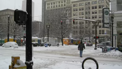
Portland Has a Bad Snow Day
Following in the footsteps of the "snowmageddon" events experienced by Atlanta in January 2014, Portland, Oregon had a surprising amount of difficulty with a small amount of snow this week.

Maui's Vacation Rental Debate Turns Ugly
Verbal attacks, misinformation campaigns and fistfights plague a high-stakes debate to convert thousands of vacation rentals into long-term housing.

Planetizen Federal Action Tracker
A weekly monitor of how Trump’s orders and actions are impacting planners and planning in America.

Chicago’s Ghost Rails
Just beneath the surface of the modern city lie the remnants of its expansive early 20th-century streetcar system.

Bend, Oregon Zoning Reforms Prioritize Small-Scale Housing
The city altered its zoning code to allow multi-family housing and eliminated parking mandates citywide.

Amtrak Cutting Jobs, Funding to High-Speed Rail
The agency plans to cut 10 percent of its workforce and has confirmed it will not fund new high-speed rail projects.

LA Denies Basic Services to Unhoused Residents
The city has repeatedly failed to respond to requests for trash pickup at encampment sites, and eliminated a program that provided mobile showers and toilets.
Urban Design for Planners 1: Software Tools
This six-course series explores essential urban design concepts using open source software and equips planners with the tools they need to participate fully in the urban design process.
Planning for Universal Design
Learn the tools for implementing Universal Design in planning regulations.
planning NEXT
Appalachian Highlands Housing Partners
Mpact (founded as Rail~Volution)
City of Camden Redevelopment Agency
City of Astoria
City of Portland
City of Laramie