


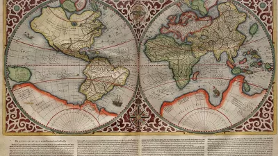
A new exhibition on Greco-Roman mapmaking at the Institute for the Study of the Ancient World in New York examines the relationship between geographic and metaphysical world views.
"Long before people could look upon Earth from afar, completing a full orbit every 90 minutes, the Greeks and the Romans of antiquity had to struggle to understand their world’s size and shape," writes John Noble Wilford. "Their approaches differed: the philosophical Greeks, it has been said, measured the world by the stars; the practical, road-building Romans by milestones."
A new exhibition, “Measuring and Mapping Space: Geographic Knowledge in Greco-Roman Antiquity,” which runs through Jan. 5 at the Institute for the Study of the Ancient World in New York City, seeks to explore the cognitive foundation underlying mapmaking, from the ancient world to the present.
"All in all, whether guided by the stars or by imperial roads, the Greeks and the Romans did well in preparing the way to geographic knowledge of worlds known and unknown, real and imaginary," he notes. "They anticipated modern concepts of mapmaking: anything that can be spatially conceived can be mapped."
FULL STORY: The World as They Knew It

Mapped: Every Building in the United States
Using data from Microsoft, the New York Times has published an online map showing the placement of every building in the country, in a simple black and white format.

Friday Eye Candy: Charting Road Maps By Hand
In the days before Google Maps, when AAA TripTiks and Thomas Guides ruled the planet…
Map-Correcting App Shows 'The True Size Of' Places
Typical world maps badly misrepresent the size of countries; a new web app shows their true scale.

Maui's Vacation Rental Debate Turns Ugly
Verbal attacks, misinformation campaigns and fistfights plague a high-stakes debate to convert thousands of vacation rentals into long-term housing.

Planetizen Federal Action Tracker
A weekly monitor of how Trump’s orders and actions are impacting planners and planning in America.

In Urban Planning, AI Prompting Could be the New Design Thinking
Creativity has long been key to great urban design. What if we see AI as our new creative partner?

Florida Seniors Face Rising Homelessness Risk
High housing costs are pushing more seniors, many of them on a fixed income, into homelessness.

Massachusetts Budget Helps Close MBTA Budget Gap
The budget signed by Gov. Maura Healey includes $470 million in MBTA funding for the next fiscal year.

Milwaukee Launches Vision Zero Plan
Seven years after the city signed its Complete Streets Policy, the city is doubling down on its efforts to eliminate traffic deaths.
Urban Design for Planners 1: Software Tools
This six-course series explores essential urban design concepts using open source software and equips planners with the tools they need to participate fully in the urban design process.
Planning for Universal Design
Learn the tools for implementing Universal Design in planning regulations.
Gallatin County Department of Planning & Community Development
Heyer Gruel & Associates PA
JM Goldson LLC
City of Camden Redevelopment Agency
City of Astoria
Transportation Research & Education Center (TREC) at Portland State University
Jefferson Parish Government
Camden Redevelopment Agency
City of Claremont