


Planning professor Doug Kelbaugh lives in one of the few neighborhoods outside Manhattan with a perfect 100 Walk Score. His brother's house in South Carolina has a Walk Score of 1. Kelbaugh reflects on the extremes, and what they mean.
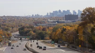
Kelbaugh explains that his neighborhood in Ann Arbor, Michigan is an extreme outlier:
"Even though there are no full neighborhoods with a score of 100 in this or any other U.S. city outside of Manhattan, there are individual addresses that achieve the perfect score. Urban neighborhoods in cities like Boston, San Francisco and Seattle are full of such addresses. And at least one place in Ann Arbor, our downtown condo in the Armory on E. Ann St. ..."
From his house, Kelbaugh says that he can walk to a farmers market, a major university (his workplace), a library, concert halls, the restaurants and shops on Main Street, the local hospital, and nearby intercity bus and train stations. His brother, on the other hand, has to use one of his two cars to get anywhere because he lives in a development with an extreme suburban configuration.
"So what?" writes Kelbaugh. "Well, I would contend our walkable lifestyle is healthier, safer, cheaper, more convenient, efficient, and pleasant. But that’s a relatively subjective comparison. What’s a more objective claim is our smaller ecological footprint."
Read more over at cnu.org.
FULL STORY: Two Brothers, Two Radically Different Walk Scores

Video: Time to Urbanize Suburbia
The Washington Post's Ezra Klein suggests readers watch this 20-minute TED video featuring Georgia Tech's Ellen Dunham Jones, author of "Retrofitting Suburbia." Jones talks to the importance of making suburbs greener by retrofitting to urbanize them.

What the ‘Walk Score’ Misses
A popular walkability assessment omits key factors that impact different demographics and can direct development resources to already wealthy neighborhoods.
Orlando Pledges to Improve Walkability
A city report highlights successes and failures in building safer transportation infrastructure and reducing VMT in 2023.

Maui's Vacation Rental Debate Turns Ugly
Verbal attacks, misinformation campaigns and fistfights plague a high-stakes debate to convert thousands of vacation rentals into long-term housing.

Planetizen Federal Action Tracker
A weekly monitor of how Trump’s orders and actions are impacting planners and planning in America.

San Francisco Suspends Traffic Calming Amidst Record Deaths
Citing “a challenging fiscal landscape,” the city will cease the program on the heels of 42 traffic deaths, including 24 pedestrians.

Opinion: What San Francisco’s Proposed ‘Family Zoning’ Could Really Mean
Mayor Lurie is using ‘family zoning’ to encourage denser development and upzoning — but could the concept actually foster community and more human-scale public spaces?

Jacksonville Launches First Autonomous Transit Shuttle in US
A fleet of 14 fully autonomous vehicles will serve a 3.5-mile downtown Jacksonville route with 12 stops.

‘Big, Beautiful Bill’ Guts EV Tax Credits
The bill eliminates federal subsidies for electric vehicle buyers and charging stations.
Urban Design for Planners 1: Software Tools
This six-course series explores essential urban design concepts using open source software and equips planners with the tools they need to participate fully in the urban design process.
Planning for Universal Design
Learn the tools for implementing Universal Design in planning regulations.
Gallatin County Department of Planning & Community Development
Heyer Gruel & Associates PA
JM Goldson LLC
City of Camden Redevelopment Agency
City of Astoria
Transportation Research & Education Center (TREC) at Portland State University
Jefferson Parish Government
Camden Redevelopment Agency
City of Claremont