


By removing auto traffic from two key streets, the plan for a 10-acre park in the heart of downtown Cleveland seeks to weave together the city's 'lackluster' Public Square and help boost a downtown revival.
James Corner Field Operations, Cleveland-based LAND Studio, and transportation consulting firm Nelson/Nygaard have developed an ambitious scheme to unite the four disconnected squares that make up Cleveland's historic Public Square by closing Ontario Street and Superior Avenue to automobiles. "In the design, tree-lined pathways and grassy hills weave the square together," explains Chris Bentley. "The programming aims to make it a true civic space."
"While redevelopment efforts in the 1990s failed to produce the public interest that comes with a true civic renewal, planners today are focused on parks and cultural experiences," he adds. "The designers of Public Square hope to unite citywide development gains, stitching together a lively downtown with a leafy civic space."
“We’re trying to optimize all of these catalytic projects that are happening around Public Square,” said LAND Studio senior project director Nora Romanoff. “If we’re doing our job right, absolutely this is a park that spurs all of these other things that have nothing to do with the park, but at the same time have everything to do with the park.”
FULL STORY: ONE PARK TO BIND THEM ALL

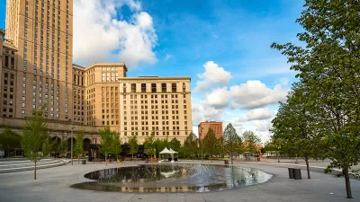
Cleveland's Renovated Public Square Opening June 30
The $50 million renovation of Cleveland's Public Square, designed by James Corner Field Operations, will open in time for the Republican National Convention.
An In-Depth Look at One of America's Preeminent Landscape Architects
The Atlantic's Eric Jaffe centers on James Corner's latest work in Cleveland's Public Square, and goes to describe his other well-known projects, including the High Line, and transformations of public parks and urban spaces throughout the country.
Feds Want Their Money Back After Cleveland Changes Public Square Plans
The city of Cleveland knew that the Federal Transit Administration expected buses to run through Public Square. Now that there will be no buses, the FTA says there will be no grant money.

Maui's Vacation Rental Debate Turns Ugly
Verbal attacks, misinformation campaigns and fistfights plague a high-stakes debate to convert thousands of vacation rentals into long-term housing.

Planetizen Federal Action Tracker
A weekly monitor of how Trump’s orders and actions are impacting planners and planning in America.

In Urban Planning, AI Prompting Could be the New Design Thinking
Creativity has long been key to great urban design. What if we see AI as our new creative partner?

King County Supportive Housing Program Offers Hope for Unhoused Residents
The county is taking a ‘Housing First’ approach that prioritizes getting people into housing, then offering wraparound supportive services.

Researchers Use AI to Get Clearer Picture of US Housing
Analysts are using artificial intelligence to supercharge their research by allowing them to comb through data faster. Though these AI tools can be error prone, they save time and housing researchers are optimistic about the future.

Making Shared Micromobility More Inclusive
Cities and shared mobility system operators can do more to include people with disabilities in planning and operations, per a new report.
Urban Design for Planners 1: Software Tools
This six-course series explores essential urban design concepts using open source software and equips planners with the tools they need to participate fully in the urban design process.
Planning for Universal Design
Learn the tools for implementing Universal Design in planning regulations.
planning NEXT
Appalachian Highlands Housing Partners
Gallatin County Department of Planning & Community Development
Mpact (founded as Rail~Volution)
City of Camden Redevelopment Agency
City of Astoria
City of Portland
City of Laramie