


Cartographic Grounds, a recent exhibition at the Harvard Graduate School of Design — now online at Places — seeks to "reconcile the precision and instrumentality of the plan with the geographic and territorial scope of the map."
"The ascendance of 'mapping' and data visualization in design culture has changed the way architects, landscape architects and urban designers communicate ideas about buildings and landscapes, often privileging abstract forces and flows over the material conditions of the site," writes curator Jill Desimini. "We have an even greater challenge now, as our drawings are required to be interactive, to make sense of big data, and to describe increasingly complex systems."
"As design extends its purview to cartography, it is time once again to look closely at maps and plans, to immerse ourselves in their beauty but also to uncover their projective potential."
Desimini explores a range of cartographic practices, from a 13th-century view of the British Isles to contemporary data visualization.
FULL STORY: Cartographic Grounds: Projecting the Landscape Imaginary


Visualizing the Coronavirus Pandemic
Mapping of the crisis is producing a fascinating and important trove of cartographic records.
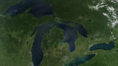
Friday Eye Candy: Full-Color, HD Videos Taken from Space
For the first time, full-color videos of the earth's surface will be made available to the public, with added options for paying customers. The imagery comes from two cameras on the International Space Station.

China Submerged: Mapping Nightmare Sea Levels
Cartographer Jeffrey Linn has compiled maps of how coastal China would look under risen seas. Over 40 percent of the country's population lives in potentially affected regions.

Maui's Vacation Rental Debate Turns Ugly
Verbal attacks, misinformation campaigns and fistfights plague a high-stakes debate to convert thousands of vacation rentals into long-term housing.

Planetizen Federal Action Tracker
A weekly monitor of how Trump’s orders and actions are impacting planners and planning in America.

In Urban Planning, AI Prompting Could be the New Design Thinking
Creativity has long been key to great urban design. What if we see AI as our new creative partner?

The Vast Potential of the Right-of-Way
One writer argues that the space between two building faces is the most important element of the built environment.

Florida Seniors Face Rising Homelessness Risk
High housing costs are pushing more seniors, many of them on a fixed income, into homelessness.

Massachusetts Budget Helps Close MBTA Budget Gap
The budget signed by Gov. Maura Healey includes $470 million in MBTA funding for the next fiscal year.
Urban Design for Planners 1: Software Tools
This six-course series explores essential urban design concepts using open source software and equips planners with the tools they need to participate fully in the urban design process.
Planning for Universal Design
Learn the tools for implementing Universal Design in planning regulations.
Gallatin County Department of Planning & Community Development
Heyer Gruel & Associates PA
JM Goldson LLC
City of Camden Redevelopment Agency
City of Astoria
Transportation Research & Education Center (TREC) at Portland State University
Jefferson Parish Government
Camden Redevelopment Agency
City of Claremont