


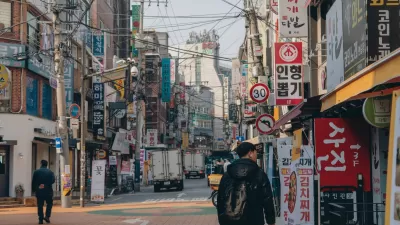
A time when your mobile phone can help you navigate the homogenous corridors of an indoor mall as easily as the route that got you there is, seemingly, not far off, as Seoul unveils an app that can navigate the city both above and below street level.
Elizabeth Woyke examines the soon to be released free mobile application, called Fing, that, "could set a new standard for city navigation guides around the world."
According to Woyke, "Street-level navigation taps the phone's GPS like a typical mapping
app." But it's when you leave the gaze of GPS tracking satellites that the innovation begins: "in places where GPS doesn't work, such as underground and deep
inside shopping malls, Fing switches to Wi-Fi-based indoor positioning
to track users' locations and provide directions."
"By making malls and underground markets easily navigable, Fing's
creators hope to encourage shopping and socializing. The app is backed
by the Korea Trade Network (KTNET), a subsidiary of Korea's
international trade association."
But not all of its potential uses are tied to extracting more dollars from your wallet. Woyke notes that, "Another major use of the app could end up being emergency aid. A
one-click feature in Fing will send a text message to the nearest police
or fire department. The message will include a request for help and the
coordinates of the user's location for expedited rescue."
FULL STORY: Citywide Indoor Navigation Is Closer Than You Think


Seoul’s Urban Parks Blossom with Books
The Reading in Seoul Garden event invited residents to enjoy free reading and relaxation activities, including digital and live programs, in scenic parks, fostering a sense of community amid the city’s autumn landscapes.
The Basement Apartments of Seoul’s Urban Poor
The lives of Seoul's poorest residents in squalid below-ground housing are brought out of the shadows in the film "Parasite."

'No Driving Day' in Seoul Means Free Transit Rides
South Korea has made public transit a key part of its approach to cleaning the air.

Planetizen Federal Action Tracker
A weekly monitor of how Trump’s orders and actions are impacting planners and planning in America.

Maui's Vacation Rental Debate Turns Ugly
Verbal attacks, misinformation campaigns and fistfights plague a high-stakes debate to convert thousands of vacation rentals into long-term housing.

San Francisco Suspends Traffic Calming Amidst Record Deaths
Citing “a challenging fiscal landscape,” the city will cease the program on the heels of 42 traffic deaths, including 24 pedestrians.

Amtrak Rolls Out New Orleans to Alabama “Mardi Gras” Train
The new service will operate morning and evening departures between Mobile and New Orleans.

The Subversive Car-Free Guide to Trump's Great American Road Trip
Car-free ways to access Chicagoland’s best tourist attractions.

San Antonio and Austin are Fusing Into one Massive Megaregion
The region spanning the two central Texas cities is growing fast, posing challenges for local infrastructure and water supplies.
Urban Design for Planners 1: Software Tools
This six-course series explores essential urban design concepts using open source software and equips planners with the tools they need to participate fully in the urban design process.
Planning for Universal Design
Learn the tools for implementing Universal Design in planning regulations.
Heyer Gruel & Associates PA
JM Goldson LLC
Custer County Colorado
City of Camden Redevelopment Agency
City of Astoria
Transportation Research & Education Center (TREC) at Portland State University
Jefferson Parish Government
Camden Redevelopment Agency
City of Claremont